
Kiitos, että tuet tätä sivustoa ❤️
Tee lahjoitus
Tee lahjoitus
Topografinen kartta Agate
Napsauta karttaa nähdäksesi korkeus.
Kiitos, että tuet tätä sivustoa ❤️
Tee lahjoitus
Tee lahjoitus
Tietoja tästä kartasta
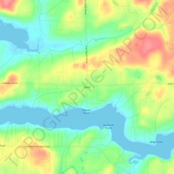
Nimi: Topografinen kartta Agate, korkeus, helpotus.
Paikka: Agate, Mason County, Washington, United States (47.19343 -123.03237 47.23343 -122.99237)
Keskimääräinen korkeus: 32 m
Minimi korkeus: -4 m
Maksimi korkeus: 81 m
Kiitos, että tuet tätä sivustoa ❤️
Tee lahjoitus
Tee lahjoitus
Muut topografiset kartat
Napsauta karttaa nähdäksesi sen topografian, sen korkeus ja sen helpotuksen.
Mount Skokomish Wilderness
United States > Washington > Mason County
Mount Skokomish Wilderness is located in the southeast corner of Olympic National Forest, just north of Lake Cushman. It consists of two long rocky ridges running roughly northeast to southwest. Elevations range from about 2,000 feet (609.6 m) to 6,434 feet (1,961.1 m) at the peak of Mount Skokomish on the…
Keskimääräinen korkeus: 1 058 m
Kiitos, että tuet tätä sivustoa ❤️
Tee lahjoitus
Tee lahjoitus