
Tee lahjoitus
Topografinen kartta Tba
Napsauta karttaa nähdäksesi korkeus.
Tee lahjoitus
Tietoja tästä kartasta
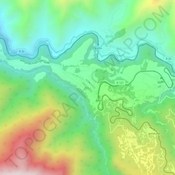
Nimi: Topografinen kartta Tba, korkeus, helpotus.
Paikka: Tba, Borjomi Municipality, Samtskhe-Javakheti, Georgia (41.78100 43.42297 41.82100 43.46297)
Keskimääräinen korkeus: 1 207 m
Minimi korkeus: 874 m
Maksimi korkeus: 1 848 m
Tee lahjoitus
Muut topografiset kartat
Napsauta karttaa nähdäksesi sen topografian, sen korkeus ja sen helpotuksen.
Bakuriani
Georgia > Samtskhe-Javakheti > Borjomi Municipality
Bakuriani (Georgian: ბაკურიანი) is a daba and a ski resort in the Borjomi district of Georgia. It is located on the northern slope of the Trialeti Range, at an elevation of 1,700 meters (5,576 feet) above sea level.
Keskimääräinen korkeus: 1 756 m
Tee lahjoitus
Bakuriani
Georgia > Samtskhe-Javakheti > Borjomi Municipality
Bakuriani (Georgian: ბაკურიანი) is a daba and a ski resort in the Borjomi district of Georgia. It is located on the northern slope of the Trialeti Range, at an elevation of 1,700 meters (5,576 feet) above sea level.
Keskimääräinen korkeus: 1 756 m