
Tee lahjoitus
Topografinen kartta Ballarat
Napsauta karttaa nähdäksesi korkeus.
Tee lahjoitus
Ballarat
Ballarat has a moderate oceanic climate (Köppen climate classification Cfb) with four distinct seasons. Its elevation, ranging between 400 and 630 metres (1,310 and 2,070 feet) above sea level, causes its mean monthly temperatures to tend to be on average 3 to 5 °C (5 to 9 °F) below those of Melbourne, especially in winter. The mean daily maximum temperature for January is 25.1 °C (77 °F), while the mean minimum is 10.9 °C (52 °F). In July, the mean maximum is 10.0 °C (50 °F); average July minimum is 3.2 °C (38 °F). Ballarat has 55.2 clear days annually, with the grand majority in summer and early autumn. Ballarat has very rainy winters.
Tee lahjoitus
Tietoja tästä kartasta
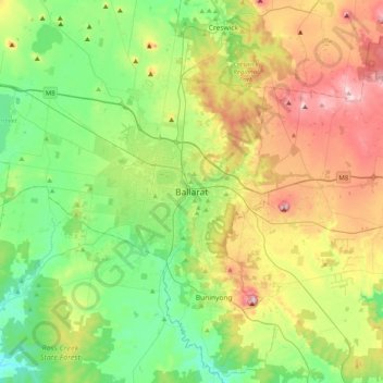
Nimi: Topografinen kartta Ballarat, korkeus, helpotus.
Paikka: Ballarat, Victoria, 3350, Australia (-37.72230 143.70056 -37.40230 144.02056)
Keskimääräinen korkeus: 470 m
Minimi korkeus: 325 m
Maksimi korkeus: 740 m
Tee lahjoitus
Muut topografiset kartat
Napsauta karttaa nähdäksesi sen topografian, sen korkeus ja sen helpotuksen.
City of Melbourne
Melbourne's topography is characterized by a diverse landscape that transitions from flat coastal plains to rolling hills and mountainous regions. The city is situated at the northern end of Port Phillip Bay, where the terrain is predominantly flat, facilitating urban development. As one moves eastward, the…
Keskimääräinen korkeus: 18 m
Melbourne
Melbourne is also prone to isolated convective showers forming when a cold pool crosses the state, especially if there is considerable daytime heating. These showers are often heavy and can include hail, squalls, and significant drops in temperature, but they often pass through very quickly with a rapid…
Keskimääräinen korkeus: 185 m
Tee lahjoitus
Tee lahjoitus
Dandenong Ranges National Park - Ferntree Gully
Australia > Victoria > Montrose
The topography consists of a series of ridges dissected by deeply cut streams. Sheltered gullies in the south of the range are home to temperate rain forest, fern gullies and Mountain Ash forest Eucalyptus regnans, whereas the drier ridges and exposed northern slopes are covered by dry sclerophyll forest of…
Keskimääräinen korkeus: 345 m
Tee lahjoitus
Mount Buller
Due to its far south-western location in the alpine region, Mount Buller is more susceptible to cold airmasses which allow it to record some of the lowest maximum temperatures and daytime readings in the country, despite being considerably lower in elevation than other mountain sites to the north-east. On 5…
Keskimääräinen korkeus: 824 m
Tee lahjoitus
Castlemaine
The Castlemaine goldfields' legendary prosperity raised expectations of Castlemaine becoming Victoria's second city. That is reflected in imposing buildings erected in the town's first few years. Though the rich alluvial diggings were largely exhausted within 15–20 years causing the town's population to…
Keskimääräinen korkeus: 319 m
Tee lahjoitus
Tee lahjoitus
Tee lahjoitus
Tee lahjoitus
Grampians National Park
Mount William is known within the gliding community for the "Grampians Wave", a weather phenomenon that sometimes enables glider pilots to reach extreme altitudes of the order of 28,000 ft (8,500 m). This predominantly occurs during the months of May, June, September and October when strong westerly winds flow…
Keskimääräinen korkeus: 262 m
Toolangi
Toolangi has a cold rainforest climate, significantly cooler and wetter than Melbourne due to elevation (of 595 metres) and being outside of the Yarra rainshadow; with annual cloud cover resembling that of Southern England in the British Isles and the Pacific Northwest of North America, more than the typical…
Keskimääräinen korkeus: 562 m
Tee lahjoitus
Tee lahjoitus
Tee lahjoitus
Tee lahjoitus
Tee lahjoitus
Tee lahjoitus
Tee lahjoitus
Tee lahjoitus
Tee lahjoitus
Tee lahjoitus
Tee lahjoitus
Trentham
Trentham is a small town in the Shire of Hepburn and Shire of Moorabool local government area, Victoria, Australia. At the 2016 census, Trentham had a population of 1,180, with a median age of 55 years. Located at an altitude of 700 metres (2,297 ft), the town is 87 kilometres (54 mi) north-west of Melbourne.
Keskimääräinen korkeus: 702 m
Tee lahjoitus
Tee lahjoitus
Tee lahjoitus
Tee lahjoitus
Tee lahjoitus
Tee lahjoitus