
Tee lahjoitus
Topografinen kartta Port Arthur
Napsauta karttaa nähdäksesi korkeus.
Tee lahjoitus
Port Arthur
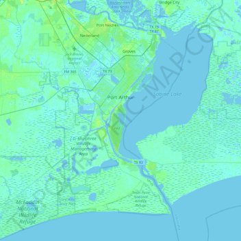
Port Arthur sits in a low-lying coastal area of the Gulf Coast, characterized by its flat, marshy terrain. The city is located at an average elevation of just 8 feet (2 meters) above sea level, with parts of the surrounding region even closer to sea level. Its topography is dominated by wetlands, tidal marshes, and the estuaries of Sabine Lake and the Neches River, with vast stretches of flat, low-lying land interspersed by canals and small bayous. This terrain makes the area particularly susceptible to flooding, especially during storm surges from hurricanes or heavy rainfall. The region is also known for its proximity to the Gulf of Mexico, influencing its coastal landscape with sandy stretches and the presence of islands like Pleasure Island.
Tee lahjoitus
Tietoja tästä kartasta
Nimi: Topografinen kartta Port Arthur, korkeus, helpotus.
Paikka: Port Arthur, Jefferson County, Texas, United States (29.63312 -94.10660 30.03235 -93.81135)
Keskimääräinen korkeus: 2 m
Minimi korkeus: -5 m
Maksimi korkeus: 14 m
Tee lahjoitus
Muut topografiset kartat
Napsauta karttaa nähdäksesi sen topografian, sen korkeus ja sen helpotuksen.