
Tee lahjoitus
Topografinen kartta Sorrento Valley
Napsauta karttaa nähdäksesi korkeus.
Tee lahjoitus
Tietoja tästä kartasta
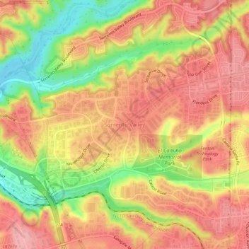
Nimi: Topografinen kartta Sorrento Valley, korkeus, helpotus.
Keskimääräinen korkeus: 88 m
Minimi korkeus: 11 m
Maksimi korkeus: 134 m
Tee lahjoitus
Muut topografiset kartat
Napsauta karttaa nähdäksesi sen topografian, sen korkeus ja sen helpotuksen.
Cabrillo National Monument
United States > California > San Diego County > San Diego
The Old Point Loma Lighthouse is the highest point in the park and has been a San Diego icon since 1855. The lighthouse was closed in 1891, and the New Point Loma Lighthouse opened at a lower elevation, as fog and low clouds often obscured the light at its location 129 meters (422 feet) above sea level. The…
Keskimääräinen korkeus: 13 m
Lake Murray Reservoir
United States > California > San Diego County > San Diego > San Carlos
Keskimääräinen korkeus: 178 m
San Diego River
United States > California > San Diego County > San Diego
Keskimääräinen korkeus: 133 m
Tee lahjoitus
Los Peñasquitos Canyon Preserve
United States > California > San Diego County > San Diego > Sorrento Valley
Keskimääräinen korkeus: 95 m
Tee lahjoitus
Torrey Pines State Natural Reserve
United States > California > San Diego County > San Diego
Keskimääräinen korkeus: 37 m