
Tee lahjoitus
Topografinen kartta Málaga
Napsauta karttaa nähdäksesi korkeus.
Tee lahjoitus
Málaga
Like many of the military fortifications that were constructed in Islamic Spain, the Alcazaba of Málaga featured a quadrangular plan. It was protected by an outer and inner wall, both supported by rectangular towers, between which a covered walkway led up the slope to the Gibralfaro (this was the only exchange between the two sites). Due to its rough and awkward hillside topography, corridors throughout the site provided a means of communications for administrative and defensive operations, also affording privacy to the palatial residential quarters.
Tee lahjoitus
Tietoja tästä kartasta
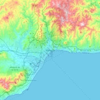
Nimi: Topografinen kartta Málaga, korkeus, helpotus.
Paikka: Málaga, Málaga-Costa del Sol, Malaga, Andalusia, 29008, Spain (36.56130 -4.58164 36.88130 -4.26164)
Keskimääräinen korkeus: 215 m
Minimi korkeus: -1 m
Maksimi korkeus: 1 019 m
Tee lahjoitus
Muut topografiset kartat
Napsauta karttaa nähdäksesi sen topografian, sen korkeus ja sen helpotuksen.
Tee lahjoitus
Tee lahjoitus
Tee lahjoitus
Tee lahjoitus