
Tee lahjoitus
Topografinen kartta Carryduff
Napsauta karttaa nähdäksesi korkeus.
Tee lahjoitus
Tietoja tästä kartasta
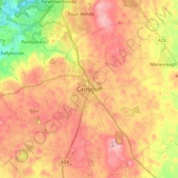
Nimi: Topografinen kartta Carryduff, korkeus, helpotus.
Keskimääräinen korkeus: 110 m
Minimi korkeus: 3 m
Maksimi korkeus: 187 m
Tee lahjoitus
Muut topografiset kartat
Napsauta karttaa nähdäksesi sen topografian, sen korkeus ja sen helpotuksen.
Magheraconluce
United Kingdom > Northern Ireland > County Down > Annahilt
Keskimääräinen korkeus: 112 m
Tee lahjoitus
Tee lahjoitus
Stormont Estate
United Kingdom > Northern Ireland > County Down > Dundonald
Keskimääräinen korkeus: 64 m
Tee lahjoitus
Ballymartin
United Kingdom > Northern Ireland > County Down > Ballymartin
Keskimääräinen korkeus: 29 m
Tollymore Forest
United Kingdom > Northern Ireland > County Down > Bryansford
Keskimääräinen korkeus: 163 m
Tee lahjoitus
Ballycullen
United Kingdom > Northern Ireland > County Down > Newtownards > Ballycullen
Keskimääräinen korkeus: 49 m
Tee lahjoitus
Ballybarnes
United Kingdom > Northern Ireland > County Down > Bradshaw's Brae
Keskimääräinen korkeus: 116 m
Lagan Valley AONB
United Kingdom > Northern Ireland > County Down > Ballyskeagh
Keskimääräinen korkeus: 66 m
Tee lahjoitus
Blaris (Castlereagh Upper portion)
United Kingdom > Northern Ireland > County Down > Hillhall
Keskimääräinen korkeus: 65 m
Scrabo Tower
United Kingdom > Northern Ireland > County Down > Newtownards
The tower's style is called Scottish Baronial by most recent authors.: "... mysteriously designed in the Scottish baronial style ..." The article in the Illustrated London News of 1857 says "... in the style of a Scottish chateau ...", whereas the article in the Dublin Builder of 1865 calls it "Scotch…
Keskimääräinen korkeus: 39 m
Burren River
United Kingdom > Northern Ireland > County Down > Castlewellan
Keskimääräinen korkeus: 85 m
Tee lahjoitus
Mourne Esplanade Amentity Area
United Kingdom > Northern Ireland > County Down > Kilkeel
Keskimääräinen korkeus: 14 m
Tee lahjoitus