
Tee lahjoitus
Topografinen kartta Relief
Napsauta karttaa nähdäksesi korkeus.
Tee lahjoitus
Tietoja tästä kartasta
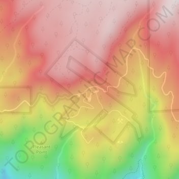
Nimi: Topografinen kartta Relief, korkeus, helpotus.
Paikka: Relief, Nevada County, California, United States (39.35199 -120.87117 39.37199 -120.85117)
Keskimääräinen korkeus: 1 193 m
Minimi korkeus: 771 m
Maksimi korkeus: 1 426 m
Tee lahjoitus
Muut topografiset kartat
Napsauta karttaa nähdäksesi sen topografian, sen korkeus ja sen helpotuksen.
Truckee
United States > California > Nevada County
Truckee is characterized by its dramatic topography set in the Sierra Nevada mountain range. The town sits at an elevation of approximately 5,817 feet (1,774 meters), surrounded by a stunning landscape of rugged mountains, rolling hills, and expansive forested areas. Prominent features include Donner Pass,…
Keskimääräinen korkeus: 1 918 m
Tee lahjoitus
Tee lahjoitus
Grass Valley
United States > California > Nevada County
Grass Valley is a city in Nevada County, California, United States. Situated at roughly 2,500 feet (760 m) in elevation in the western foothills of the Sierra Nevada mountain range, this northern Gold Country city is 57 miles (92 km) by car from Sacramento, 64 miles (103 km) from Sacramento International…
Keskimääräinen korkeus: 775 m
Alta Sierra
United States > California > Nevada County > Alta Sierra
Alta Sierra was laid out by property developers in the 1960s. Alta Sierra is a golf course community, with homes built around the Alta Sierra Country Club, a semi-private 18 hole course built in 1964. The community has a member-owned airport with a 2800 foot runway. The community is located just east of…
Keskimääräinen korkeus: 603 m
Alta Sierra
United States > California > Nevada County > Alta Sierra
Alta Sierra was laid out by property developers in the 1960s. Alta Sierra is a golf course community, with homes built around the Alta Sierra Country Club, a semi-private 18 hole course built in 1964. The community has a member-owned airport with a 2800-foot runway. The community is located just east of…
Keskimääräinen korkeus: 603 m
Tee lahjoitus
Grass Valley
United States > California > Nevada County
Grass Valley is a city in Nevada County, California, United States. As of the 2010 United States Census, its population was 12,860. Situated at roughly 2,500 feet (760 m) in elevation in the western foothills of the Sierra Nevada mountain range, this northern Gold Country city is 57 miles (92 km) by car from…
Keskimääräinen korkeus: 775 m
Grass Valley
United States > California > Nevada County
Grass Valley is a city in Nevada County, California, United States. Situated at roughly 2,500 feet (760 m) in elevation in the western foothills of the Sierra Nevada mountain range, this northern Gold Country city is 57 miles (92 km) by car from Sacramento, 64 miles (103 km) from Sacramento International…
Keskimääräinen korkeus: 775 m
Tee lahjoitus