Geolocate

Topografinen kartta Katoomba Falls

Napsauta karttaa nähdäksesi korkeus.

Tietoja tästä kartasta

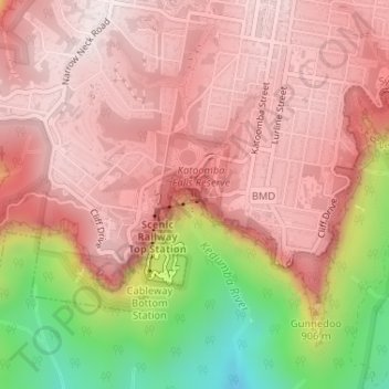
Nimi: Topografinen kartta Katoomba Falls, korkeus, helpotus.

Paikka: Katoomba Falls, Blue Mountains City Council, New South Wales, 2780, Australia (-33.72791 150.30447 -33.72781 150.30457)

Keskimääräinen korkeus: 837 m

Minimi korkeus: 418 m

Maksimi korkeus: 1 033 m

Muut topografiset kartat

Napsauta karttaa nähdäksesi sen topografian, sen korkeus ja sen helpotuksen.

Sydney

Australia > New South Wales

Sydney's topography is characterized by a diverse landscape that seamlessly blends coastal features with inland plateaus. The city is divided into two primary regions: the relatively flat Cumberland Plain to the south and west of Sydney Harbour, and the elevated Hornsby Plateau to the north. The Cumberland…

Keskimääräinen korkeus: 53 m

Newcastle

Australia > New South Wales > Newcastle

Keskimääräinen korkeus: 5 m

Sydney

Australia > New South Wales > Sydney

Keskimääräinen korkeus: 23 m

Laurieton

Australia > New South Wales

Keskimääräinen korkeus: 46 m

Orange

Australia > New South Wales

Orange is a city in the Central Tablelands region of New South Wales, Australia. It is 254 km (158 mi) west of the state capital, Sydney [206 km (128 mi) on a great circle], at an altitude of 862 metres (2,828 ft). Orange had an estimated urban population of 40,493 as of June 2018 making the city a significant…

Keskimääräinen korkeus: 852 m

Blue Mountains City Council

Australia > New South Wales

Keskimääräinen korkeus: 521 m

Port Macquarie

Australia > New South Wales

Keskimääräinen korkeus: 5 m

Manly

Australia > New South Wales

Keskimääräinen korkeus: 17 m

Illawarra

Australia > New South Wales

Keskimääräinen korkeus: 234 m

Moruya

Australia > New South Wales

Keskimääräinen korkeus: 37 m

Bowral

Australia > New South Wales

Keskimääräinen korkeus: 690 m

Penrith

Australia > New South Wales > Penrith

Penrith is a city in New South Wales, Australia, located in Greater Western Sydney, 55 kilometres (31 mi) west of the Sydney central business district on the banks of the Nepean River, on the outskirts of the Cumberland Plain. Its elevation is 32 metres (105 ft).

Keskimääräinen korkeus: 34 m

Epping

Australia > New South Wales

Keskimääräinen korkeus: 96 m

Hazelbrook

Australia > New South Wales

Hazelbrook is a town in New South Wales, Australia (Elevation: 675 metres) It is located 91 kilometres west of Sydney and 16 kilometres east of Katoomba in the Blue Mountains on the Great Western Highway.

Keskimääräinen korkeus: 610 m

Balala

Australia > New South Wales

Keskimääräinen korkeus: 912 m

Clothiers Creek

Australia > New South Wales

Keskimääräinen korkeus: 39 m

Gwydir Shire Council

Australia > New South Wales

Keskimääräinen korkeus: 431 m

Campbelltown

Australia > New South Wales

Keskimääräinen korkeus: 96 m

Crookwell

Australia > New South Wales

Crookwell is a small town located in the Southern Tablelands of New South Wales, Australia, in the Upper Lachlan Shire. At the 2016 census, Crookwell had a population of 2,641. The town is at a relatively high altitude of 887 metres and there are several snowfalls during the winter months. The nearest major…

Keskimääräinen korkeus: 904 m

Lismore

Australia > New South Wales

Keskimääräinen korkeus: 23 m

Blue Mountains

Australia > New South Wales

A sandstone plateau dominated by a landscape of endless eucalyptus forests, the Blue Mountains are located at the top of a 470-million-year-old quartzite. In the Permian period, a shallow sea covered the region, when rivers brought shales, siltstones and mudstones. Then during the Mesozoic period, rivers…

Keskimääräinen korkeus: 566 m

Iluka

Australia > New South Wales

Keskimääräinen korkeus: 2 m

Goulburn

Australia > New South Wales

Owing to its elevation, Goulburn has an oceanic climate (Cfb) with warm summers and cool winters; with a high diurnal range. Its climate is variable much of the year, though generally dry with maximum temperatures ranging from 11.8 °C (53.2 °F) in July to 28.3 °C (82.9 °F) in January. Rainfall is…

Keskimääräinen korkeus: 666 m

Redfern

Australia > New South Wales

Keskimääräinen korkeus: 30 m

Mullumbimby

Australia > New South Wales

Keskimääräinen korkeus: 29 m

Rose Bay

Australia > New South Wales

Keskimääräinen korkeus: 31 m

Bega Valley Shire Council

Australia > New South Wales

Keskimääräinen korkeus: 370 m

Talbingo

Australia > New South Wales

Keskimääräinen korkeus: 740 m

Woolomin

Australia > New South Wales

Keskimääräinen korkeus: 632 m

Kempsey

Australia > New South Wales

Keskimääräinen korkeus: 5 m

Tullymorgan

Australia > New South Wales

Keskimääräinen korkeus: 45 m

Woronora

Australia > New South Wales > Sydney

Woronora Plateau, is a geographical region adjacent to the Sydney Plain. Slightly higher in altitude, it is capped with Hawkesbury Sandstone. The Woronora River flows through the deeply dissected plateau to the Georges River from near the sources of the Port Hacking, within the Sutherland Shire.

Keskimääräinen korkeus: 65 m

Rose Seidler House

Australia > New South Wales > Sydney

Keskimääräinen korkeus: 153 m

Central Coast Council

Australia > New South Wales

Keskimääräinen korkeus: 103 m

St Georges Basin

Australia > New South Wales

Keskimääräinen korkeus: 18 m

Wingham

Australia > New South Wales

Keskimääräinen korkeus: 47 m

Armidale

Australia > New South Wales

Keskimääräinen korkeus: 1 036 m

Yass

Australia > New South Wales

Yass is located 280 km south-west of Sydney, on the Hume Highway. The Yass River, which is a tributary of the Murrumbidgee River, flows through the town. Yass is 59 km from Canberra; lying at an elevation of 505 m AMSL.

Keskimääräinen korkeus: 533 m

Katoomba

Australia > New South Wales

Keskimääräinen korkeus: 904 m

Kosciuszko National Park

Australia > New South Wales

Keskimääräinen korkeus: 883 m

Bathurst Regional Council

Australia > New South Wales

Keskimääräinen korkeus: 845 m

Tenterfield Shire Council

Australia > New South Wales

Keskimääräinen korkeus: 565 m

Fairfield City Council

Australia > New South Wales

Keskimääräinen korkeus: 50 m

Wagga Wagga City Council

Australia > New South Wales

Keskimääräinen korkeus: 282 m

Lithgow City Council

Australia > New South Wales

Keskimääräinen korkeus: 713 m

The Entrance

Australia > New South Wales

Keskimääräinen korkeus: 5 m

Cronulla

Australia > New South Wales > Sydney

Keskimääräinen korkeus: 8 m

Tocumwal

Australia > New South Wales

Keskimääräinen korkeus: 112 m

Hardys Bay

Australia > New South Wales

Keskimääräinen korkeus: 27 m

Wollemi National Park

Australia > New South Wales

Keskimääräinen korkeus: 521 m

Ryde

Australia > New South Wales > Sydney

Keskimääräinen korkeus: 52 m

Lane Cove

Australia > New South Wales > Sydney

Keskimääräinen korkeus: 52 m

Berrigan Shire Council

Australia > New South Wales

Keskimääräinen korkeus: 115 m

Northern Beaches

Australia > New South Wales > Sydney

Keskimääräinen korkeus: 67 m

Mid-Coast Council

Australia > New South Wales

Keskimääräinen korkeus: 278 m

Khancoban

Australia > New South Wales

Keskimääräinen korkeus: 642 m

Junee

Australia > New South Wales

Keskimääräinen korkeus: 326 m

Tumbarumba

Australia > New South Wales

Keskimääräinen korkeus: 774 m

Castlereagh River

Australia > New South Wales

The Castlereagh rises 20 km west of Coonabarabran in the heart of the Warrumbungle mountains at an elevation of about 850 metres. From its commencement upstream in the mountains the river initially flows east through the town of Coonabarabran. It then arcs round south and southwesterly to the village of…

Keskimääräinen korkeus: 240 m

Dundee

Australia > New South Wales

Keskimääräinen korkeus: 1 051 m

Liverpool Range

Australia > New South Wales

Keskimääräinen korkeus: 475 m

Talofa

Australia > New South Wales

Keskimääräinen korkeus: 83 m

Bellingen

Australia > New South Wales

Keskimääräinen korkeus: 46 m

Batlow

Australia > New South Wales

Keskimääräinen korkeus: 803 m

Newcastle-Maitland

Australia > New South Wales

Keskimääräinen korkeus: 23 m

Jindera

Australia > New South Wales

Keskimääräinen korkeus: 272 m

Cudgera Creek

Australia > New South Wales

Keskimääräinen korkeus: 43 m

Maybole

Australia > New South Wales

Keskimääräinen korkeus: 1 202 m

Errowanbang

Australia > New South Wales

Keskimääräinen korkeus: 776 m

Kielvale

Australia > New South Wales

Keskimääräinen korkeus: 12 m

Oxley Island

Australia > New South Wales

Keskimääräinen korkeus: 4 m

Lake Burrendong

Australia > New South Wales

Keskimääräinen korkeus: 528 m

Wiangaree

Australia > New South Wales

Keskimääräinen korkeus: 130 m

City of Lake Macquarie

Australia > New South Wales

Keskimääräinen korkeus: 78 m

Glenbrook

Australia > New South Wales

Keskimääräinen korkeus: 168 m

Pokolbin

Australia > New South Wales

Keskimääräinen korkeus: 135 m

Parramatta

Australia > New South Wales

Keskimääräinen korkeus: 22 m

Barrington Tops

Australia > New South Wales

Keskimääräinen korkeus: 1 107 m

Cootamundra

Australia > New South Wales

Keskimääräinen korkeus: 407 m

Byron Bay

Australia > New South Wales

Byron Bay, located in northeastern New South Wales, Australia, is characterized by diverse topography shaped by its geological history. The town is part of the erosion caldera of the ancient Tweed Volcano, which erupted approximately 23 million years ago, resulting in the rich volcanic soils that define the…

Keskimääräinen korkeus: 7 m

Lismore City Council

Australia > New South Wales

Keskimääräinen korkeus: 83 m

Baulkham Hills

Australia > New South Wales

Keskimääräinen korkeus: 93 m

Council of the City of Ryde

Australia > New South Wales

Keskimääräinen korkeus: 48 m

Captains Flat

Australia > New South Wales

Keskimääräinen korkeus: 957 m

Dural

Australia > New South Wales > Sydney

Keskimääräinen korkeus: 157 m

Bredbo

Australia > New South Wales

Keskimääräinen korkeus: 929 m

Ocean Shores

Australia > New South Wales

Keskimääräinen korkeus: 12 m

Williamtown

Australia > New South Wales

Keskimääräinen korkeus: 5 m

Penrith City Council

Australia > New South Wales

Keskimääräinen korkeus: 97 m

Bywong

Australia > New South Wales

Keskimääräinen korkeus: 734 m

Nepean River

Australia > New South Wales

Keskimääräinen korkeus: 601 m

Chittaway Point

Australia > New South Wales

Keskimääräinen korkeus: 3 m

Sanctuary Point

Australia > New South Wales

Keskimääräinen korkeus: 10 m

Douglas Park

Australia > New South Wales

Keskimääräinen korkeus: 164 m

Baw Baw

Australia > New South Wales

Keskimääräinen korkeus: 699 m

Brewongle

Australia > New South Wales

Keskimääräinen korkeus: 776 m

Kerewong

Australia > New South Wales

Keskimääräinen korkeus: 335 m

The Pocket

Australia > New South Wales

Keskimääräinen korkeus: 84 m

Boat Harbour

Australia > New South Wales

Keskimääräinen korkeus: 10 m

Woodford

Australia > New South Wales > Sydney

Woodford is a village in the Blue Mountains in New South Wales, Australia, about 90 kilometres west of Sydney. Its elevation is 609 metres (1,998 ft) above sea level. It is situated on the Great Western Highway and has a railway station (opened in 1868 as Buss's Platform) on the Main Western railway line…

Keskimääräinen korkeus: 544 m