
Tee lahjoitus
Topografinen kartta Derry/Londonderry
Napsauta karttaa nähdäksesi korkeus.
Tee lahjoitus
Derry/Londonderry
Derry is characterised by its distinctively hilly topography. The River Foyle forms a deep valley as it flows through the city, making Derry a place of very steep streets and sudden, startling views. The original walled city of Londonderry lies on a hill on the west bank of the River Foyle. In the past, the river branched and enclosed this wooded hill as an island; over the centuries, however, the western branch of the river dried up and became a low-lying and boggy district that is now called the Bogside.
Tee lahjoitus
Tietoja tästä kartasta
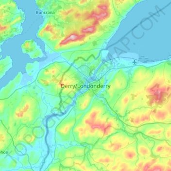
Nimi: Topografinen kartta Derry/Londonderry, korkeus, helpotus.
Keskimääräinen korkeus: 88 m
Minimi korkeus: -5 m
Maksimi korkeus: 478 m
Tee lahjoitus
Muut topografiset kartat
Napsauta karttaa nähdäksesi sen topografian, sen korkeus ja sen helpotuksen.
Drumahoe
United Kingdom > Northern Ireland > County Londonderry > Derry/Londonderry
Keskimääräinen korkeus: 46 m
Causeway Coast and Glens District
United Kingdom > Northern Ireland > County Londonderry
Keskimääräinen korkeus: 101 m
Ballymagroarty
United Kingdom > Northern Ireland > County Londonderry > Derry/Londonderry
Keskimääräinen korkeus: 73 m
Tee lahjoitus
Mid-Ulster District Council
United Kingdom > Northern Ireland > County Londonderry
Keskimääräinen korkeus: 112 m
Foyle
United Kingdom > Northern Ireland > County Londonderry > Derry/Londonderry
Keskimääräinen korkeus: 48 m
River Roe
United Kingdom > Northern Ireland > County Londonderry > Limavady
Keskimääräinen korkeus: 27 m
Tee lahjoitus
Lough Foyle
United Kingdom > Northern Ireland > County Londonderry > Londonderry/Derry
Keskimääräinen korkeus: 61 m
Foyle
United Kingdom > Northern Ireland > County Londonderry > Derry/Londonderry
Keskimääräinen korkeus: 48 m
Bay Road Park
United Kingdom > Northern Ireland > County Londonderry > Derry/Londonderry
Keskimääräinen korkeus: 19 m
Tee lahjoitus