Geolocate

Topografinen kartta Mustang

Napsauta karttaa nähdäksesi korkeus.

Tietoja tästä kartasta

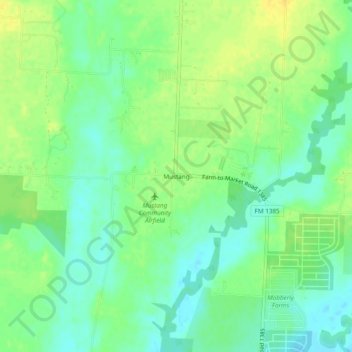
Nimi: Topografinen kartta Mustang, korkeus, helpotus.

Paikka: Mustang, Denton County, Texas, United States (33.30067 -96.92306 33.34067 -96.88306)

Keskimääräinen korkeus: 182 m

Minimi korkeus: 170 m

Maksimi korkeus: 194 m

Muut topografiset kartat

Napsauta karttaa nähdäksesi sen topografian, sen korkeus ja sen helpotuksen.

Denton

United States > Texas > Denton County

Denton is on the northern edge of the Dallas–Fort Worth metropolitan area. These three cities form the area known as the "Golden Triangle of North Texas". According to the United States Census Bureau, the city has an area of 89.316 square miles (231.33 km2), of which 87.952 square miles (227.79 km2) is land…

Keskimääräinen korkeus: 195 m

The Colony

United States > Texas > Denton County

Keskimääräinen korkeus: 175 m

Lewisville

United States > Texas > Denton County

Keskimääräinen korkeus: 160 m

Aubrey

United States > Texas > Denton County

Keskimääräinen korkeus: 197 m

Bartonville

United States > Texas > Denton County

Keskimääräinen korkeus: 198 m

Little Elm

United States > Texas > Denton County

According to the U.S. Census Bureau, it has a total area of 18.6 square miles (48.3 km2), of which 14.6 square miles (37.7 km2) is land and 4.1 square miles (10.5 km2), or 21.83%, is covered by water. Little Elm has an average elevation of 545 feet above sea level.

Keskimääräinen korkeus: 171 m

Corinth

United States > Texas > Denton County

Keskimääräinen korkeus: 180 m

Trophy Club

United States > Texas > Denton County

Keskimääräinen korkeus: 187 m

Flower Mound

United States > Texas > Denton County

Keskimääräinen korkeus: 178 m

Oak Point

United States > Texas > Denton County

Keskimääräinen korkeus: 171 m

Roanoke

United States > Texas > Denton County

Keskimääräinen korkeus: 186 m

Lake Dallas

United States > Texas > Denton County

Keskimääräinen korkeus: 169 m

Justin

United States > Texas > Denton County

Keskimääräinen korkeus: 198 m

Sanger

United States > Texas > Denton County

Keskimääräinen korkeus: 209 m

Copper Canyon

United States > Texas > Denton County

Keskimääräinen korkeus: 184 m

Shady Shores

United States > Texas > Denton County

Keskimääräinen korkeus: 165 m

Flower Mound

United States > Texas > Denton County

Keskimääräinen korkeus: 178 m

Lewisville

United States > Texas > Denton County

Lewisville is at 33°2′18″N 97°0′22″W / 33.03833°N 97.00611°W / 33.03833; -97.00611 (33.038316, −97.006232) at an elevation of about 550 feet (170 m). It has a total area of 42.5 square miles (110 km2), of which 6.1 sq mi (16 km2) is covered by water. It lies at the southern end of Denton…

Keskimääräinen korkeus: 160 m

Grapevine Lake

United States > Texas > Denton County > Grapevine > Flower Mound

Keskimääräinen korkeus: 181 m

Argyle

United States > Texas > Denton County

Keskimääräinen korkeus: 206 m

Copper Canyon

United States > Texas > Denton County

Keskimääräinen korkeus: 184 m

Krum

United States > Texas > Denton County

Keskimääräinen korkeus: 219 m

Flower Mound

United States > Texas > Denton County

Keskimääräinen korkeus: 178 m

Roanoke

United States > Texas > Denton County

Keskimääräinen korkeus: 186 m

The Colony

United States > Texas > Denton County

Keskimääräinen korkeus: 175 m

Bartonville

United States > Texas > Denton County

Keskimääräinen korkeus: 198 m

Trophy Club

United States > Texas > Denton County

Keskimääräinen korkeus: 187 m

Hills of Roanoke

United States > Texas > Denton County > Roanoke

Keskimääräinen korkeus: 180 m

Copper Canyon

United States > Texas > Denton County

Keskimääräinen korkeus: 184 m

Corinth

United States > Texas > Denton County

Keskimääräinen korkeus: 180 m

DISH

United States > Texas > Denton County

Keskimääräinen korkeus: 201 m

Argyle

United States > Texas > Denton County

Keskimääräinen korkeus: 206 m

Highland Village

United States > Texas > Denton County

Keskimääräinen korkeus: 170 m

Aubrey

United States > Texas > Denton County

Keskimääräinen korkeus: 197 m

Flower Mound

United States > Texas > Denton County

Keskimääräinen korkeus: 178 m

Fort Worth

United States > Texas > Denton County

Keskimääräinen korkeus: 213 m

The Colony

United States > Texas > Denton County

Keskimääräinen korkeus: 175 m

Denton

United States > Texas > Denton County

Denton is located on the northern edge of the Dallas–Fort Worth metropolitan area. These three cities form the area known as the "Golden Triangle of North Texas." According to the United States Census Bureau, the city has a total area of 89.316 square miles (231.33 km2), of which 87.952 square miles (227.79…

Keskimääräinen korkeus: 195 m

Argyle

United States > Texas > Denton County

Keskimääräinen korkeus: 206 m

Cross Roads

United States > Texas > Denton County

Keskimääräinen korkeus: 172 m

Westlake

United States > Texas > Denton County

Keskimääräinen korkeus: 199 m

Sanger

United States > Texas > Denton County

Keskimääräinen korkeus: 209 m

Hickory Creek

United States > Texas > Denton County > Hickory Creek

Keskimääräinen korkeus: 169 m

Westlake

United States > Texas > Denton County

Keskimääräinen korkeus: 199 m

Sequoia Park

United States > Texas > Denton County > Denton

Keskimääräinen korkeus: 198 m