
Tee lahjoitus
Topografinen kartta Zeppenfeld
Napsauta karttaa nähdäksesi korkeus.
Tee lahjoitus
Tietoja tästä kartasta
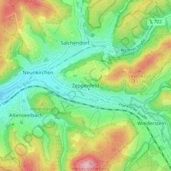
Nimi: Topografinen kartta Zeppenfeld, korkeus, helpotus.
Keskimääräinen korkeus: 336 m
Minimi korkeus: 251 m
Maksimi korkeus: 486 m
Tee lahjoitus
Muut topografiset kartat
Napsauta karttaa nähdäksesi sen topografian, sen korkeus ja sen helpotuksen.
Siegen
Germany > North Rhine-Westphalia > Kreis Siegen-Wittgenstein
The city's total land area is roughly 115 km2 (44 sq mi). Its greatest east-west span is about 12 km (7 mi), and its greatest north-south span is about 12 km (7 mi). City limits are 48 km (30 mi) long. Siegen lies at a median elevation of 290 m (951 ft) above sea level. The city's greatest elevation is the…
Keskimääräinen korkeus: 346 m
Bad Laasphe
Germany > North Rhine-Westphalia > Kreis Siegen-Wittgenstein
The highest elevation in the municipal area rises to 694 m. It lies southwest of the main town at the outlying centre of Heiligenborn.
Keskimääräinen korkeus: 464 m
Freudenberg
Germany > North Rhine-Westphalia > Kreis Siegen-Wittgenstein
Keskimääräinen korkeus: 350 m
Siegen
Germany > North Rhine-Westphalia > Kreis Siegen-Wittgenstein
The city's total land area is roughly 115 km2 (44 sq mi). Its greatest east-west span is about 12 km (7 mi), and its greatest north-south span is about 12 km (7 mi). City limits are 48 km (30 mi) long. Siegen lies at a median elevation of 290 m (951 ft) above sea level. The city's greatest elevation is the…
Keskimääräinen korkeus: 346 m
Tee lahjoitus
Dahlbruch
Germany > North Rhine-Westphalia > Kreis Siegen-Wittgenstein > Hilchenbach
Keskimääräinen korkeus: 367 m
NSG Erzebachtal
Germany > North Rhine-Westphalia > Kreis Siegen-Wittgenstein > Kreuztal > Fellinghausen
Keskimääräinen korkeus: 329 m
Kreuztal
Germany > North Rhine-Westphalia > Kreis Siegen-Wittgenstein
The town's highest elevation is the mountain Hoher Wald at 655 m above sea level. The peak is however not open to the public, as it belongs to the Bundeswehr. Other mountains are the Hölzenberg 626 m above sea level, Kindelsberg 617.9 m above sea level (the town's landmark), the Martinshardt 616.1 m above sea…
Keskimääräinen korkeus: 408 m