
Kiitos, että tuet tätä sivustoa ❤️
Tee lahjoitus
Tee lahjoitus
Topografinen kartta Jammu
Napsauta karttaa nähdäksesi korkeus.
Kiitos, että tuet tätä sivustoa ❤️
Tee lahjoitus
Tee lahjoitus
Jammu
Jammu is located at 32°44′N 74°52′E / 32.73°N 74.87°E / 32.73; 74.87. It has an average elevation of 300 m (980 ft). Jammu city lies at uneven ridges of low heights at the Shivalik hills. It is surrounded by the Shivalik range to the north, east, and southeast while the Trikuta Range surrounds it in the northwest. It is approximately 600 kilometres (370 mi) from the national capital, New Delhi.
Kiitos, että tuet tätä sivustoa ❤️
Tee lahjoitus
Tee lahjoitus
Tietoja tästä kartasta
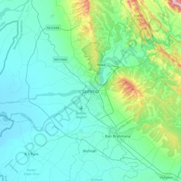
Nimi: Topografinen kartta Jammu, korkeus, helpotus.
Paikka: Jammu, Jammu district, Jammu and Kashmir, 180001, India (32.55856 74.69809 32.87856 75.01809)
Keskimääräinen korkeus: 367 m
Minimi korkeus: 255 m
Maksimi korkeus: 987 m
Kiitos, että tuet tätä sivustoa ❤️
Tee lahjoitus
Tee lahjoitus
Muut topografiset kartat
Napsauta karttaa nähdäksesi sen topografian, sen korkeus ja sen helpotuksen.