
Tee lahjoitus
Topografinen kartta Mica
Napsauta karttaa nähdäksesi korkeus.
Tee lahjoitus
Tietoja tästä kartasta
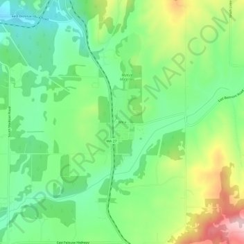
Nimi: Topografinen kartta Mica, korkeus, helpotus.
Paikka: Mica, Spokane County, Washington, 99023, United States (47.53612 -117.23106 47.57612 -117.19106)
Keskimääräinen korkeus: 772 m
Minimi korkeus: 682 m
Maksimi korkeus: 936 m
Tee lahjoitus
Muut topografiset kartat
Napsauta karttaa nähdäksesi sen topografian, sen korkeus ja sen helpotuksen.
Riverside State Park
United States > Washington > Spokane County > Spokane
Terrain in park is varied, with steep valleys along the rivers and more flat plateaus above. The Spokane River falls from approximately 1,680 feet when it enters the park in the south to approximately 1,540 feet at the Long Lake Reservoir on the northern edge of the park. Surrounding plateaus rise to 2,200…
Keskimääräinen korkeus: 645 m
Millwood
United States > Washington > Spokane County
The topography of the city is mostly flat as it lies on the floor of the Spokane Valley, though it does slope gently down towards the north. The northern edge of town is defined by the Spokane River, where the terrain promptly drops about 20 feet down to the river bank.
Keskimääräinen korkeus: 600 m
Tee lahjoitus