
Tee lahjoitus
Topografinen kartta Hafjell
Napsauta karttaa nähdäksesi korkeus.
Tee lahjoitus
Tietoja tästä kartasta
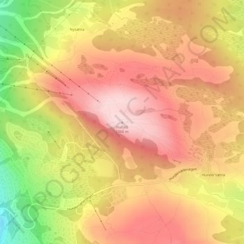
Nimi: Topografinen kartta Hafjell, korkeus, helpotus.
Paikka: Hafjell, Øyer, Innlandet, Norway (61.22962 10.52690 61.22972 10.52700)
Keskimääräinen korkeus: 962 m
Minimi korkeus: 787 m
Maksimi korkeus: 1 068 m
Tee lahjoitus
Muut topografiset kartat
Napsauta karttaa nähdäksesi sen topografian, sen korkeus ja sen helpotuksen.
Tee lahjoitus
Tee lahjoitus
Tee lahjoitus
Tee lahjoitus
Dovre
The Dovre area is in a valley at fairly high altitude and isolated from the sea by mountain ranges, giving some rain shadow effect for Dovre. Dovre, with the town Dombås, has a subarctic climate (Dfc) with sparse precipitation. The driest season is late winter and spring, and the wettest season is summer.…
Keskimääräinen korkeus: 1 195 m
Hamar
Hamar has a humid continental climate (Dfb) with fairly dry and cold winters, and comfortably warm summers. The Hamar II weather station, at an elevation of 141 metres (463 ft), started recording in 1968. The all-time high 33 °C (91 °F) was recorded in July 2018, which was the warmest month on record with…
Keskimääräinen korkeus: 445 m
Tee lahjoitus
Tee lahjoitus
Tee lahjoitus
Dovre
The Dovre area is in a valley at fairly high altitude and isolated from the sea by mountain ranges, giving some rain shadow effect for Dovre. Dovre, with the town Dombås, has a subarctic climate (Dfc) with sparse precipitation. The driest season is late winter and spring, and the wettest season is summer.…
Keskimääräinen korkeus: 1 195 m
Tee lahjoitus
Tee lahjoitus
Tee lahjoitus
Hamar
Hamar has a humid continental climate (Dfb) with fairly dry and cold winters, and comfortably warm summers. The Hamar II weather station, at an elevation of 141 metres (463 ft), started recording in 1968. The all-time high 33 °C (91 °F) was recorded in July 2018, which was the warmest month on record with…
Keskimääräinen korkeus: 445 m
Tee lahjoitus
Tee lahjoitus
Tee lahjoitus
Tee lahjoitus
Tee lahjoitus
Tee lahjoitus