
Tee lahjoitus
Topografinen kartta Fort Hunter
Napsauta karttaa nähdäksesi korkeus.
Tee lahjoitus
Tietoja tästä kartasta
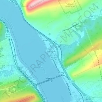
Nimi: Topografinen kartta Fort Hunter, korkeus, helpotus.
Keskimääräinen korkeus: 149 m
Minimi korkeus: 91 m
Maksimi korkeus: 381 m
Tee lahjoitus
Muut topografiset kartat
Napsauta karttaa nähdäksesi sen topografian, sen korkeus ja sen helpotuksen.
Blue Mountain
United States > Pennsylvania > Dauphin County > Middle Paxton Township
The ridge of Blue Mountain runs for 150 miles (240 km) through Pennsylvania, reaching an elevation of 2,270 feet (690 m) above sea level just north of the Pennsylvania Turnpike, near the borough of Newburg. Most of the ridgecrest, however, only reaches between 1,400 and 1,700 feet (430 and 520 m) in elevation.…
Keskimääräinen korkeus: 199 m
Clark Creek
United States > Pennsylvania > Dauphin County > Middle Paxton Township
Keskimääräinen korkeus: 135 m