
Topografinen kartta Caloundra
Napsauta karttaa nähdäksesi korkeus.
Caloundra
Caloundra, located on Queensland's Sunshine Coast, features a diverse coastal topography characterized by sandy beaches, rocky headlands, and nearby elevated terrains. The suburb of Kings Beach exemplifies this diversity, with its sandy shoreline to the south and southeast, and a rocky headland rising to about 20 meters (66 feet) to the north and northeast. The area is generally hilly, with elevations reaching over 40 meters (131 feet) in certain parts. To the west, the Mooloolah River flows eastward across Glenview towards the coast, with nearby elevations such as Meridan Hill at 140 meters (459 feet) and Mount Sippy at 180 meters (591 feet). Further southwest, Mount Mellum rises to 406 meters (1,332 feet), adding to the region's varied terrain. Additionally, the Pumicestone Passage, a narrow waterway between Bribie Island and the mainland, extends from Caloundra southward for about 35 kilometers (22 miles), contributing to the area's intricate coastal landscape.
Tietoja tästä kartasta
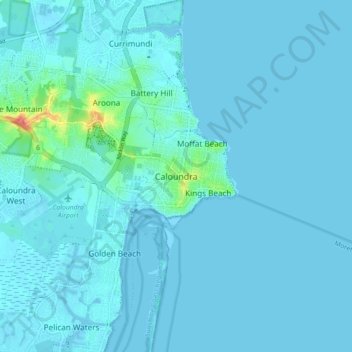
Nimi: Topografinen kartta Caloundra, korkeus, helpotus.
Keskimääräinen korkeus: 5 m
Minimi korkeus: -4 m
Maksimi korkeus: 73 m
Muut topografiset kartat
Napsauta karttaa nähdäksesi sen topografian, sen korkeus ja sen helpotuksen.
Sugar Bag Road Town Reserve
Australia > Queensland > Sunshine Coast Regional
Keskimääräinen korkeus: 19 m
Minyama
Australia > Queensland > Sunshine Coast Regional
Minyama is located within the Kawana Waters urban centre. Situated on the Mooloolah River, the suburb is almost entirely surrounded by water, and artificially constructed harbours and waterways dominate the topography. The suburb's main thoroughfare, Nicklin Way, is the location of several large retail…
Keskimääräinen korkeus: 3 m
Parklands Conservation Park
Australia > Queensland > Sunshine Coast Regional
Keskimääräinen korkeus: 49 m
Beerburrum East State Forest
Australia > Queensland > Sunshine Coast Regional
Keskimääräinen korkeus: 16 m