
Tee lahjoitus
Topografinen kartta Kings Peak
Napsauta karttaa nähdäksesi korkeus.
Tee lahjoitus
Kings Peak
Kings Peak is the highest peak in the U.S. state of Utah, with an elevation of 13,528 feet (4,123 m) NAVD 88.
Tee lahjoitus
Tietoja tästä kartasta
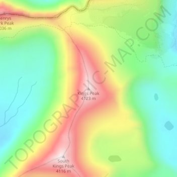
Nimi: Topografinen kartta Kings Peak, korkeus, helpotus.
Paikka: Kings Peak, Duchesne County, Utah, United States (40.77619 -110.37285 40.77629 -110.37275)
Keskimääräinen korkeus: 3 743 m
Minimi korkeus: 3 469 m
Maksimi korkeus: 4 118 m
Tee lahjoitus
Muut topografiset kartat
Napsauta karttaa nähdäksesi sen topografian, sen korkeus ja sen helpotuksen.
Roosevelt
United States > Utah > Duchesne County
Roosevelt is situated on U.S. Route 40 in the northeast corner of the state, south of the Uinta Mountains, at an elevation of 5,250 feet (1,600 m). The town was incorporated at a mass meeting of 44 citizens on 21 February 1913. From 1906 to 1914 Roosevelt was in Wasatch County, but in 1914 Duchesne County was…
Keskimääräinen korkeus: 1 553 m
Tee lahjoitus