
Tee lahjoitus
Topografinen kartta Vigo
Napsauta karttaa nähdäksesi korkeus.
Tee lahjoitus
Vigo
Vigo has a transitional climate between the oceanic climate "Cfb" and the warm-summer Mediterranean climate "Csb" according to the Köppen climate classification. Although Vigo is the rainiest city in Galicia, with its noticeable drying trend in the summer, Vigo's climate is more similar to the variant of the oceanic climate commonly seen in the Pacific Northwest region of North America. The average annual temperature in Vigo is 14 °C (57 °F). Compared to many other Galician towns, Vigo and Pontevedra experience warmer summer temperatures than A Coruña or Santiago de Compostela and milder winters than inland areas. This is due to its sheltered location, surrounded by mountains and the Illas Cíes out in the bay towards the sea. The all-time record high for the city is 40.8 °C (105 °F) set on August 7, 2016. Vigo is known for its extreme rainfall in winter. December 1978 saw 925.6 millimetres (36.44 in) fall at the weather station in a single month. During that month on 7th December, 175 millimetres (6.9 in) fell on a single day. Normal values for 1981-2010 was 1,791 millimetres (70.5 in) falling on just 129.2 days indicating heavy rain to be common. The airport where values are taken is located further inland at a considerably higher elevation (261 metres (856 ft)) than the city itself located at the coastline in the Ria de Vigo estuary, which is likely warmer year-round.
Tee lahjoitus
Tietoja tästä kartasta
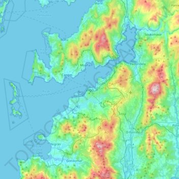
Nimi: Topografinen kartta Vigo, korkeus, helpotus.
Paikka: Vigo, Pontevedra, Galicia, 36202, Spain (42.07766 -8.88472 42.39766 -8.56472)
Keskimääräinen korkeus: 121 m
Minimi korkeus: -1 m
Maksimi korkeus: 730 m
Tee lahjoitus
Muut topografiset kartat
Napsauta karttaa nähdäksesi sen topografian, sen korkeus ja sen helpotuksen.
Vigo
Vigo has a transitional climate between the oceanic climate "Cfb" and the warm-summer Mediterranean climate "Csb" according to the Köppen climate classification. Although Vigo is the rainiest city in Galicia, with its noticeable drying trend in the summer, Vigo's climate is more similar to the variant of the…
Keskimääräinen korkeus: 137 m
Vigo
Vigo has a transitional climate between the oceanic climate "Cfb" and the warm-summer Mediterranean climate "Csb" according to the Köppen climate classification. Although Vigo is the rainiest city in Galicia, with its noticeable drying trend in the summer, Vigo's climate is more similar to the variant of the…
Keskimääräinen korkeus: 124 m
Tee lahjoitus
Vigo
Vigo has a transitional climate between the oceanic climate "Cfb" and the warm-summer Mediterranean climate "Csb" according to the Köppen climate classification. Although Vigo is the rainiest city in Galicia, with its noticeable drying trend in the summer, Vigo's climate is more similar to the variant of the…
Keskimääräinen korkeus: 137 m