
Tee lahjoitus
Topografinen kartta Grabsleben
Napsauta karttaa nähdäksesi korkeus.
Tee lahjoitus
Tietoja tästä kartasta
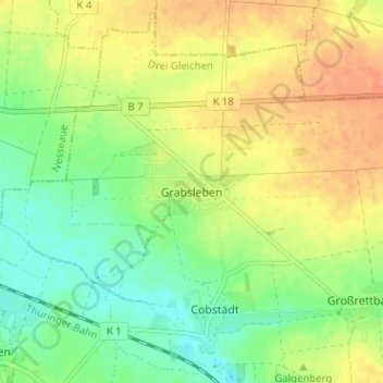
Nimi: Topografinen kartta Grabsleben, korkeus, helpotus.
Keskimääräinen korkeus: 291 m
Minimi korkeus: 272 m
Maksimi korkeus: 310 m
Tee lahjoitus
Muut topografiset kartat
Napsauta karttaa nähdäksesi sen topografian, sen korkeus ja sen helpotuksen.
Gotha
Germany > Thuringia > Landkreis Gotha
Gotha is situated in a flat landscape within the fertile Thuringian Basin. A tectonic dislocation traverses the city from north-west to south-east. Thereby, it forms three prominent hills: the 431 m high Krahnberg with the Ratsholz forest in the north-west, the hill of Friedenstein Castle in the city centre…
Keskimääräinen korkeus: 320 m
Tee lahjoitus