
Topografinen kartta Cairns
Napsauta karttaa nähdäksesi korkeus.
Cairns
South of Smithfield and inland from the Northern Beaches along the edge of the Barron River flood plain are the suburbs of Caravonica, Kamerunga, Freshwater, and Stratford. This area is sometimes referred to as Freshwater Valley, though it is actually the lower part of Redlynch Valley; further up the valley are the suburbs of Redlynch, on the western side of Redlynch Valley, and Brinsmead on the eastern side. Stratford, Freshwater, and Brinsmead are separated from Cairns city by Mount Whitfield (elevation 365 m (1,198 ft)) and Whitfield Range. Crystal Cascades and Copperlode Falls Dam are also behind this range. (Kuranda, a town on the Barron River on the western side of the Macalister Range, forms part of the Cairns economic catchment but is in the Tablelands local government area and is not part of the Cairns urban area.)
Tietoja tästä kartasta
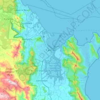
Nimi: Topografinen kartta Cairns, korkeus, helpotus.
Paikka: Cairns, Cairns Regional, Queensland, 4870, Australia (-17.08067 145.61219 -16.76067 145.93219)
Keskimääräinen korkeus: 176 m
Minimi korkeus: -1 m
Maksimi korkeus: 1 284 m
Muut topografiset kartat
Napsauta karttaa nähdäksesi sen topografian, sen korkeus ja sen helpotuksen.
City of Brisbane
Brisbane's topography is characterized by a series of hills and ranges that define its landscape. The city is situated on a low-lying floodplain, with the Brisbane River meandering through its heart, creating a winding course with many steep curves from the southwest to its mouth at Moreton Bay in the east.…
Keskimääräinen korkeus: 71 m
Sunshine Coast Regional
The Sunshine Coast Regional area in Queensland, Australia, features a diverse topography that ranges from coastal plains to rugged hinterlands. Along the coastline, the terrain is predominantly flat, with average elevations around 20 meters (66 feet) above sea level. Inland, the landscape transitions to…
Keskimääräinen korkeus: 56 m
Mornington Island
The general topography of the island, which lies on the eastern (Queensland) side of the Gulf of Carpentaria, is flat with the maximum elevation of 150 metres (490 ft). The island is fringed by mangrove forests and contains 10 estuaries, all in near pristine condition.
Keskimääräinen korkeus: 3 m
Stanthorpe
Owing to its elevation, Stanthorpe features a subtropical highland climate (Cfb). At an altitude of 811 metres (2,661 ft), Stanthorpe holds the record for the lowest temperature recorded in Queensland at −10.6 °C (12.9 °F) on 23 June 1961.
Keskimääräinen korkeus: 831 m
Bribie Island
Australia > Queensland > Brisbane
Bribie Island, located in Queensland, Australia, is a low-lying, elongated landmass stretching approximately 34 kilometers (21 miles) in length and up to 8 kilometers (5 miles) at its widest point. Composed predominantly of coastal sand plains, the island features two large, low-lying dunes extending…
Keskimääräinen korkeus: 6 m
Rocksberg
The Caboolture River flows from north to east through the locality with Zillmans Crossing (27°07′18″S 152°51′32″E / 27.1218°S 152.8588°E / -27.1218; 152.8588 (Zillmans Crossing)) being a former ford (now a low-level bridge) across the river. The ford was part of the Old North Road (now…
Keskimääräinen korkeus: 172 m
Brisbane River
The RAAF also perform a practice session in the days preceding the event, serving as an opportunity to both practice beforehand and also promote Riverfire. One of the most popular RAAF aircraft to perform at Riverfire was the F-111 which was known for performing a 'dump-and-burn' above the city. The final…
Keskimääräinen korkeus: 235 m
Roma
Roma experiences a humid subtropical climate (Köppen: Cfa, Trewartha: Cfal); with hot summers with moderate rains; warm to hot, relatively dry springs and autumns; and mild, dry winters. Its location on the far south of the Carnarvon Range at an elevation of 299 metres above sea level means that it is cooler…
Keskimääräinen korkeus: 315 m