
Tee lahjoitus
Topografinen kartta San Marcos
Napsauta karttaa nähdäksesi korkeus.
Tee lahjoitus
San Marcos
San Marcos is characterized by its diverse topography, which includes rolling hills, lush riverbanks, and scenic limestone outcroppings. The city is situated at an elevation of approximately 600 feet above sea level, providing a backdrop of gently undulating terrain that slopes towards the banks of the San Marcos River. This river, one of the longest spring-fed rivers in the country, weaves through the landscape, creating rich riparian habitats and offering a natural corridor for both wildlife and recreational activities. The surrounding hills are dotted with oak and cedar trees, contributing to the region’s picturesque views and offering numerous opportunities for hiking and outdoor exploration. Overall, the interplay of water and elevated landforms creates a dynamic and inviting environment in San Marcos.
Tee lahjoitus
Tietoja tästä kartasta
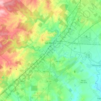
Nimi: Topografinen kartta San Marcos, korkeus, helpotus.
Paikka: San Marcos, Hays County, Texas, 78666, United States (29.77658 -98.01907 29.96063 -97.84196)
Keskimääräinen korkeus: 208 m
Minimi korkeus: 148 m
Maksimi korkeus: 323 m
Tee lahjoitus
Muut topografiset kartat
Napsauta karttaa nähdäksesi sen topografian, sen korkeus ja sen helpotuksen.