
Tee lahjoitus
Topografinen kartta Enchanted Rock
Napsauta karttaa nähdäksesi korkeus.
Tee lahjoitus
Enchanted Rock
Enchanted Rock is a pink granite mountain located in the Llano Uplift about 17 miles (27 km) north of Fredericksburg, Texas and 24 miles (39 km) south of Llano, Texas, United States. Enchanted Rock State Natural Area, which includes Enchanted Rock and surrounding land, spans the border between Gillespie and Llano counties, south of the Llano River. Enchanted Rock covers roughly 640 acres (260 ha) and rises around 425 feet (130 m) above the surrounding terrain to an elevation of 1,825 feet (556 m) above sea level. It is the largest pink granite monadnock in the United States. Enchanted Rock State Natural Area, a part of the Texas state park system, includes 1,644 acres (665 ha). In 1936, the area was designated a Recorded Texas Historic Landmark. In 1971, Enchanted Rock was designated as a National Natural Landmark by the National Park Service.
Tee lahjoitus
Tietoja tästä kartasta
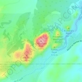
Nimi: Topografinen kartta Enchanted Rock, korkeus, helpotus.
Paikka: Enchanted Rock, Llano County, Texas, United States (30.50642 -98.81885 30.50652 -98.81875)
Keskimääräinen korkeus: 453 m
Minimi korkeus: 414 m
Maksimi korkeus: 554 m
Tee lahjoitus
Muut topografiset kartat
Napsauta karttaa nähdäksesi sen topografian, sen korkeus ja sen helpotuksen.