
Tee lahjoitus
Topografinen kartta Philadelphia
Napsauta karttaa nähdäksesi korkeus.
Tee lahjoitus
Tietoja tästä kartasta
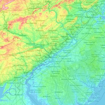
Nimi: Topografinen kartta Philadelphia, korkeus, helpotus.
Paikka: Philadelphia, Pennsylvania, 19140, United States (39.31145 -75.83265 40.71145 -74.43265)
Keskimääräinen korkeus: 68 m
Minimi korkeus: -4 m
Maksimi korkeus: 496 m
Tee lahjoitus
Muut topografiset kartat
Napsauta karttaa nähdäksesi sen topografian, sen korkeus ja sen helpotuksen.
Pittsburgh
United States > Pennsylvania > Allegheny County
Pittsburgh, located in Allegheny County, Pennsylvania, is characterized by its distinct and varied topography, shaped by the confluence of the Allegheny, Monongahela, and Ohio rivers. The city itself is situated at an average elevation of approximately 764 feet (233 meters) above sea level, with the terrain…
Keskimääräinen korkeus: 303 m
Philadelphia
United States > Pennsylvania > Philadelphia County
Philadelphia, located at the confluence of the Delaware and Schuylkill Rivers, features a diverse topography characterized by its gentle slopes and valleys. The city lies on the Atlantic Seaboard Fall Line, transitioning from the flat Coastal Plain to the more rugged Piedmont region. This unique geographical…
Keskimääräinen korkeus: 44 m
Chester County
According to the U.S. Census Bureau, the county has a total area of 759 square miles (1,970 km2), of which 751 square miles (1,950 km2) is land and 8.7 square miles (23 km2) (1.1%) is water. The topography consists of rolling hills and valleys and it is part of the region known as the Piedmont.
Keskimääräinen korkeus: 124 m
Tee lahjoitus
Allegheny County
Allegheny has a humid continental climate which is hot-summer, (Dfa) except in higher elevations, where it is warm-summer (Dfb).
Keskimääräinen korkeus: 325 m
State College
United States > Pennsylvania > Centre County
State College is situated at an elevation of approximately 1,200 feet (370 m) above sea level. According to the U.S. Census Bureau, the borough has a total area of 4.5 square miles (12 km2), all of it land. It is surrounded by large tracts of farmland, and an expanse of Appalachian Mountain ranges and forests.…
Keskimääräinen korkeus: 351 m
Tee lahjoitus
Norristown
United States > Pennsylvania > Montgomery County
In the Köppen climate classification, the borough has a humid subtropical climate (Cfa) according to recent temperature numbers. The Trewartha climate classification now has the climate as Do (oceanic because only seven months are above 50 °F.) The hardiness zone is 7a or 7b depending upon elevation.
Keskimääräinen korkeus: 50 m
Jim Thorpe
United States > Pennsylvania > Carbon County
In the deeps of the geologic timescale the two shorelines of the Lehigh River occupied by the 19th-century towns of Mauch Chunk and East Mauch Chunk were situated on the bottom of an ancient river-fed tarn, a mountain lake which filled the valley on the west bank and covered the relative flatlands on the east…
Keskimääräinen korkeus: 327 m
Tee lahjoitus
State College
United States > Pennsylvania > Centre County
State College is situated at an elevation of approximately 1,200 feet (370 m) above sea level. According to the U.S. Census Bureau, the borough has a total area of 4.5 square miles (12 km2), all of it land. It is surrounded by large tracts of farmland, and an expanse of Appalachian Mountain ranges and forests.…
Keskimääräinen korkeus: 351 m
Tee lahjoitus
Carlisle
United States > Pennsylvania > Cumberland County
Carlisle is located slightly northeast of the center of Cumberland County at 40°12′9″N 77°11′42″W / 40.20250°N 77.19500°W / 40.20250; -77.19500 (40.202553, −77.195016) at an elevation of 479 feet (146 m).[24][25] The borough lies in the Cumberland Valley, a section of the Great…
Keskimääräinen korkeus: 148 m
Bucks County
According to the Trewartha climate classification system, the Piedmont (United States) section of Bucks County, which is located roughly northwest of U.S. Route 1, has a Temperate Continental Climate with hot and slightly humid summers, cold winters and year-around precipitation (Dcao). Dcao climates are…
Keskimääräinen korkeus: 98 m
Willow Grove
United States > Pennsylvania > Montgomery County > Upper Moreland Township > Willow Grove
Keskimääräinen korkeus: 88 m
Tee lahjoitus
North Huntingdon Township
United States > Pennsylvania > Westmoreland County
Keskimääräinen korkeus: 325 m
Tee lahjoitus
Tee lahjoitus
Erie County
Most of the county has a warm-summer humid continental climate (Dfb), except at lower elevations near enough to the lake, where a hot-summer humid continental climate (Dfa) exists. Average monthly temperatures in downtown Erie range from 26.4 °F in January to 70.8 °F in July, while in Corry they range from…
Keskimääräinen korkeus: 248 m
Tee lahjoitus
Wayne County
The highest elevation in the county, 2,659 ft (810 m), is the summit of Mount Ararat in Orson. Two other summits at the north end of the same ridge also exceed 2,640 ft (800 m) in elevation. The county's lowest point, at approximately 680 ft (210 m) above sea level, is along the Delaware, near Wayne County's…
Keskimääräinen korkeus: 436 m
Bath
United States > Pennsylvania > Northampton County
Bath is also 100 miles (160 km) southwest of New York City and 60 miles (96 km) northwest of Philadelphia. It is also located near Wind Gap as well as the Delaware and Lehigh water gaps. Bath's elevation is 432 feet (132 m) above sea level as of 2011. The Borough is hilly and has many steep roads. There are…
Keskimääräinen korkeus: 152 m
Tee lahjoitus
Bethel Park
United States > Pennsylvania > Allegheny County
According to the U.S. Census Bureau, the borough had a total area of 11.7 square miles (30 km2), all of it land. Its average elevation is 1,197 feet (365 m) above sea level. Bethel Park lies at the margin between the Pittsburgh Low Plateau and Waynesburg Hills Sections of the Allegheny Plateau physiographic…
Keskimääräinen korkeus: 347 m
Pottstown
United States > Pennsylvania > Montgomery County
Pottstown lacks an official weather station as administered from the regional National Weather Service office in Mount Holly, New Jersey. Temperatures average a little higher than the closest official weather station serving Reading from Bern Township, Berks County due to the difference in latitude and…
Keskimääräinen korkeus: 69 m
Tee lahjoitus
Tee lahjoitus
Hazleton
United States > Pennsylvania > Luzerne County
In 1818, anthracite coal deposits were discovered in nearby Beaver Meadows by prospectors Nathaniel Beach and Tench Coxe. This caught the attention of railroad developers in Philadelphia. A young engineer from New York named Ariovistus "Ario" Pardee was hired to survey the topography of Beaver Meadows and…
Keskimääräinen korkeus: 510 m
Cheltenham Township
United States > Pennsylvania > Montgomery County
According to the U.S. Census Bureau, the township has a total area of 9.0 square miles (23 km2), all land. The area consists of rolling hills and also features a few streams flowing through it, most notably the Tookany Creek. The highest elevation is 411 feet (125 m), at the intersection of Sunset and Lindley…
Keskimääräinen korkeus: 80 m
Allegheny County
Allegheny has a humid continental climate which is hot-summer, (Dfa) except in higher elevations, where it is warm-summer (Dfb).
Keskimääräinen korkeus: 325 m
Lehigh County
Lehigh County borders two Appalachian mountain ridges. To the north, the county borders Blue Mountain, which has an altitude of 1,300 to 1,604 feet (396 to 489 m). To the south, it is bordered by South Mountain, which has an altitude of 700 to 1,100 feet (210 to 340 m) and cuts through the southern portions of…
Keskimääräinen korkeus: 186 m
Tee lahjoitus
Tee lahjoitus
Tee lahjoitus
Seneca
United States > Pennsylvania > Venango County > Cranberry Township > Seneca
Keskimääräinen korkeus: 437 m
Somerset County
Somerset County along with Garrett County is one of the snowiest inhabited locations in the United States, with the highest elevations of the county averaging 150+ inches of snow each winter. The county's elevation and general proximity to both the Great Lakes and the Atlantic Ocean causes snow from both…
Keskimääräinen korkeus: 632 m
Tee lahjoitus
Luzerne County
The Wyoming Valley, also referred to as the Anthracite Valley Section of Pennsylvania, runs directly through Luzerne County. It extends from the northeastern border (with Lackawanna County) to the western border (with Columbia County). The valley is flat (at the Susquehanna Basin) and rises from 512 feet (156…
Keskimääräinen korkeus: 402 m
Tee lahjoitus
Tee lahjoitus
Centre County
Centre County has a humid continental climate (Dfb/Dfa at lower elevations).
Keskimääräinen korkeus: 427 m
Tee lahjoitus
Tee lahjoitus
Tee lahjoitus
Tee lahjoitus
Sullivan County
Elevation ranges from 2593 ft at North Mountain in Davidson Township to 779 ft on Loyalsock Creek at the Lycoming County line. The county is served by Pennsylvania Route 42, Pennsylvania Route 87, Pennsylvania Route 154, Pennsylvania Route 487, and U.S. Route 220. The major rivers in the county are Loyalsock…
Keskimääräinen korkeus: 491 m
Tee lahjoitus
Pike County
The terrain rises rapidly from the river valley in the east to the rolling foothills of the Poconos in the west. The highest point is one of two unnamed hills in Greene Township that top out at approximately 2,110 feet (643 m) above sea level. The lowest elevation is approximately 340 feet (103.6 m), at the…
Keskimääräinen korkeus: 361 m
Tee lahjoitus
Erie County
Most of the county has a warm-summer humid continental climate (Dfb), except at lower elevations near enough to the lake, where a hot-summer humid continental climate (Dfa) exists. Average monthly temperatures in downtown Erie range from 26.4 °F in January to 70.8 °F in July, while in Corry they range from…
Keskimääräinen korkeus: 248 m
Tee lahjoitus
Monroe County
According to the Trewartha climate classification system, the higher elevation Pocono Plateau Region of Monroe County has a Temperate Continental climate (Dc) with warm summers (b), cold winters (o) and year-around precipitation (Dcbo). Dcbo climates are characterized by at least one month having an average…
Keskimääräinen korkeus: 361 m
Tee lahjoitus