
Tee lahjoitus
Topografinen kartta Saint Simons
Napsauta karttaa nähdäksesi korkeus.
Tee lahjoitus
Tietoja tästä kartasta
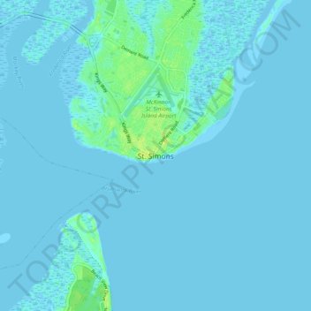
Nimi: Topografinen kartta Saint Simons, korkeus, helpotus.
Paikka: Saint Simons, Glynn County, Georgia, 31522, United States (31.09538 -81.42952 31.17538 -81.34952)
Keskimääräinen korkeus: 2 m
Minimi korkeus: -3 m
Maksimi korkeus: 14 m
Tee lahjoitus
Muut topografiset kartat
Napsauta karttaa nähdäksesi sen topografian, sen korkeus ja sen helpotuksen.
Brunswick
United States > Georgia > Glynn County
The city is the lowest in the U.S. state of Georgia, with an elevation of only 10 to 14 feet (3.0 to 4.3 m) above sea level. According to the U.S. Census Bureau, Brunswick's land area is 32.4 square miles (83.8 km2). Its total area is 42.4 square miles (109.8 km2); 10.0 square miles (26.0 km2) of this is water.
Keskimääräinen korkeus: 2 m
Tee lahjoitus