
Tee lahjoitus
Topografinen kartta Stonewall
Napsauta karttaa nähdäksesi korkeus.
Tee lahjoitus
Tietoja tästä kartasta
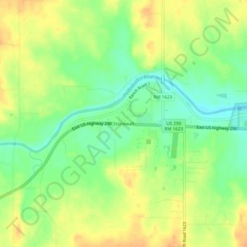
Nimi: Topografinen kartta Stonewall, korkeus, helpotus.
Paikka: Stonewall, Gillespie County, Texas, 78671, United States (30.21593 -98.68462 30.25593 -98.64462)
Keskimääräinen korkeus: 452 m
Minimi korkeus: 433 m
Maksimi korkeus: 469 m
Tee lahjoitus
Muut topografiset kartat
Napsauta karttaa nähdäksesi sen topografian, sen korkeus ja sen helpotuksen.
Fredericksburg
United States > Texas > Gillespie County
Enchanted Rock is a geographical landmark 27 km (17 mi) north of Fredericksburg in Llano County. The rock is a huge, pink granite exfoliation dome that rises 425 ft (130 m) above the surrounding land, has a summit elevation of 1,825 ft (556 m) above sea level, and covers 640 acres (260 ha). Enchanted Rock…
Keskimääräinen korkeus: 526 m
Tee lahjoitus