Geolocate

Topografinen kartta Dillans Scrub

Napsauta karttaa nähdäksesi korkeus.

Tietoja tästä kartasta

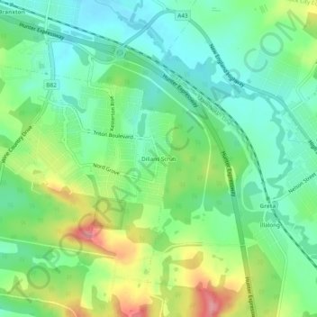
Nimi: Topografinen kartta Dillans Scrub, korkeus, helpotus.

Paikka: Dillans Scrub, Cessnock City Council, New South Wales, 2334, Australia (-32.70167 151.34778 -32.66167 151.38778)

Keskimääräinen korkeus: 67 m

Minimi korkeus: 31 m

Maksimi korkeus: 135 m

Muut topografiset kartat

Napsauta karttaa nähdäksesi sen topografian, sen korkeus ja sen helpotuksen.

Sydney

Australia > New South Wales

Sydney's topography is characterized by a diverse landscape that seamlessly blends coastal features with inland plateaus. The city is divided into two primary regions: the relatively flat Cumberland Plain to the south and west of Sydney Harbour, and the elevated Hornsby Plateau to the north. The Cumberland…

Keskimääräinen korkeus: 53 m

Box Hill

Australia > New South Wales > Sydney

Keskimääräinen korkeus: 45 m

Newcastle

Australia > New South Wales > Newcastle

Keskimääräinen korkeus: 5 m

Picton

Australia > New South Wales

Keskimääräinen korkeus: 227 m

Northern Beaches Council

Australia > New South Wales > Sydney

Keskimääräinen korkeus: 67 m

Central Coast Council

Australia > New South Wales

Keskimääräinen korkeus: 103 m

Blue Mountains National Park

Australia > New South Wales

Keskimääräinen korkeus: 456 m

Whale Beach

Australia > New South Wales > Sydney

Keskimääräinen korkeus: 17 m

Drake Village

Australia > New South Wales

Keskimääräinen korkeus: 534 m

Mount Warrigal

Australia > New South Wales

The suburb includes "Native Dog Hill" and its surrounding areas. To the north and west are the shores of Lake Illawarra. With its high elevation above the surrounding areas and close proximity to the lake, the suburb has excellent views of the Pacific Ocean to the east, Lake Illawarra and the Illawarra…

Keskimääräinen korkeus: 12 m

Katoomba

Australia > New South Wales

Keskimääräinen korkeus: 904 m

Riverstone

Australia > New South Wales

Keskimääräinen korkeus: 26 m

Ocean Shores

Australia > New South Wales

Keskimääräinen korkeus: 12 m

Cudal

Australia > New South Wales

Keskimääräinen korkeus: 466 m

Orange

Australia > New South Wales

Orange is a city in the Central Tablelands region of New South Wales, Australia. It is 254 km (158 mi) west of the state capital, Sydney [206 km (128 mi) on a great circle], at an altitude of 862 metres (2,828 ft). Orange had an estimated urban population of 40,493 as of June 2018 making the city a significant…

Keskimääräinen korkeus: 852 m

Northern Beaches

Australia > New South Wales > Sydney

Keskimääräinen korkeus: 67 m

Clouds Creek

Australia > New South Wales

Keskimääräinen korkeus: 594 m

Hanging Rock

Australia > New South Wales

Keskimääräinen korkeus: 894 m

Lake Canobolas

Australia > New South Wales

Keskimääräinen korkeus: 937 m

Urliup

Australia > New South Wales

Keskimääräinen korkeus: 110 m

Port Macquarie

Australia > New South Wales

Keskimääräinen korkeus: 5 m

Blaxland

Australia > New South Wales

Keskimääräinen korkeus: 214 m

Shoalhaven River

Australia > New South Wales

Keskimääräinen korkeus: 384 m

Capertee

Australia > New South Wales

Keskimääräinen korkeus: 757 m

Bowral

Australia > New South Wales

Keskimääräinen korkeus: 690 m

Blue Mountains City Council

Australia > New South Wales

Keskimääräinen korkeus: 521 m

Moore Park

Australia > New South Wales > Sydney

Keskimääräinen korkeus: 43 m

Kurnell

Australia > New South Wales > Sydney

Keskimääräinen korkeus: 4 m

Epping

Australia > New South Wales

Keskimääräinen korkeus: 96 m

Mangrove Mountain

Australia > New South Wales

Keskimääräinen korkeus: 194 m

Shellharbour

Australia > New South Wales

Keskimääräinen korkeus: 9 m

Upper Crystal Creek

Australia > New South Wales

Keskimääräinen korkeus: 188 m

Megalong Valley

Australia > New South Wales > Blackheath > Medlow Bath

Keskimääräinen korkeus: 662 m

Morangarell

Australia > New South Wales

Keskimääräinen korkeus: 241 m

Millers Point

Australia > New South Wales > Sydney

Keskimääräinen korkeus: 14 m

Lake Munmorah

Australia > New South Wales

Keskimääräinen korkeus: 10 m

Parramatta

Australia > New South Wales

Keskimääräinen korkeus: 22 m

Goulburn

Australia > New South Wales

Owing to its elevation, Goulburn has an oceanic climate (Cfb) with warm summers and cool winters; with a high diurnal range. Its climate is variable much of the year, though generally dry with maximum temperatures ranging from 11.8 °C (53.2 °F) in July to 28.3 °C (82.9 °F) in January. Rainfall is…

Keskimääräinen korkeus: 666 m

Kosciuszko National Park

Australia > New South Wales

Keskimääräinen korkeus: 883 m

Alstonville

Australia > New South Wales

Keskimääräinen korkeus: 131 m

Tenterfield Shire Council

Australia > New South Wales

Keskimääräinen korkeus: 565 m

Glen Innes

Australia > New South Wales

Keskimääräinen korkeus: 1 083 m

Moss Vale

Australia > New South Wales

Keskimääräinen korkeus: 673 m

Taree

Australia > New South Wales

Keskimääräinen korkeus: 17 m

Kunghur

Australia > New South Wales

Keskimääräinen korkeus: 145 m

Nimbin

Australia > New South Wales

Keskimääräinen korkeus: 235 m

Brunswick Heads

Australia > New South Wales

Keskimääräinen korkeus: 7 m

Wollongbar

Australia > New South Wales

Keskimääräinen korkeus: 134 m

Quakers Hill

Australia > New South Wales

Keskimääräinen korkeus: 35 m

Kempsey Shire Council

Australia > New South Wales

Keskimääräinen korkeus: 372 m

Goulburn Mulwaree Council

Australia > New South Wales

Keskimääräinen korkeus: 681 m

Brisbane Grove

Australia > New South Wales

Keskimääräinen korkeus: 655 m

Billinudgel

Australia > New South Wales

Keskimääräinen korkeus: 21 m

Bondi Beach

Australia > New South Wales > Sydney

Keskimääräinen korkeus: 31 m

Wamboin

Australia > New South Wales

Keskimääräinen korkeus: 795 m

Dubbo

Australia > New South Wales

Keskimääräinen korkeus: 318 m

Glossodia

Australia > New South Wales

Keskimääräinen korkeus: 50 m

Glen Innes Severn Council

Australia > New South Wales

Keskimääräinen korkeus: 918 m

Pindimar

Australia > New South Wales

Keskimääräinen korkeus: 18 m

Warialda

Australia > New South Wales

Keskimääräinen korkeus: 420 m

Gulgong

Australia > New South Wales

Keskimääräinen korkeus: 454 m

Millfield

Australia > New South Wales

Keskimääräinen korkeus: 190 m

Eastern Creek

Australia > New South Wales

Keskimääräinen korkeus: 60 m

Murringo

Australia > New South Wales

Keskimääräinen korkeus: 502 m

Kew

Australia > New South Wales

Keskimääräinen korkeus: 65 m

Coffs Harbour City Council

Australia > New South Wales

Keskimääräinen korkeus: 207 m

Byron Bay

Australia > New South Wales

Byron Bay, located in northeastern New South Wales, Australia, is characterized by diverse topography shaped by its geological history. The town is part of the erosion caldera of the ancient Tweed Volcano, which erupted approximately 23 million years ago, resulting in the rich volcanic soils that define the…

Keskimääräinen korkeus: 7 m

Lismore City Council

Australia > New South Wales

Keskimääräinen korkeus: 83 m

Bathurst Regional Council

Australia > New South Wales

Keskimääräinen korkeus: 845 m

Liverpool

Australia > New South Wales > Sydney

Keskimääräinen korkeus: 14 m

Nowra

Australia > New South Wales

Keskimääräinen korkeus: 21 m

Leura

Australia > New South Wales

Leura's elevation of 985 metres (3,232 ft) AHD  leads to occasional snowfall in winter and a climate that reflects all four seasons distinctly.

Keskimääräinen korkeus: 880 m

Mudgee

Australia > New South Wales

Keskimääräinen korkeus: 535 m

Coogee

Australia > New South Wales

Keskimääräinen korkeus: 35 m

Holsworthy

Australia > New South Wales > Sydney

Keskimääräinen korkeus: 121 m

Northbridge

Australia > New South Wales > Sydney

Keskimääräinen korkeus: 53 m

North Rothbury

Australia > New South Wales

Keskimääräinen korkeus: 66 m

Wollondilly Shire Council

Australia > New South Wales

Keskimääräinen korkeus: 464 m

Sydney

Australia > New South Wales > Sydney

Keskimääräinen korkeus: 23 m

Ballina Shire Council

Australia > New South Wales

Keskimääräinen korkeus: 39 m

Lane Cove National Park

Australia > New South Wales > Sydney

The park includes areas of land which are part of Ku-ring-gai, Ryde, and Hornsby local government areas with small areas of the park in Willoughby, Lane Cove and Hunter's Hill local government areas on the banks of the lower reaches of the river. The park is surrounded on all sides by developed suburban areas…

Keskimääräinen korkeus: 81 m

Ingleburn

Australia > New South Wales > Sydney

Keskimääräinen korkeus: 56 m

West Ryde

Australia > New South Wales

Keskimääräinen korkeus: 43 m

Blue Mountains

Australia > New South Wales

A sandstone plateau dominated by a landscape of endless eucalyptus forests, the Blue Mountains are located at the top of a 470-million-year-old quartzite. In the Permian period, a shallow sea covered the region, when rivers brought shales, siltstones and mudstones. Then during the Mesozoic period, rivers…

Keskimääräinen korkeus: 566 m

Dungog Shire Council

Australia > New South Wales

Keskimääräinen korkeus: 232 m

Wyrallah

Australia > New South Wales

Keskimääräinen korkeus: 36 m

Grafton

Australia > New South Wales

Keskimääräinen korkeus: 5 m

Hurstville

Australia > New South Wales > Sydney

Keskimääräinen korkeus: 50 m

Moruya

Australia > New South Wales

Keskimääräinen korkeus: 37 m

Bawley Point

Australia > New South Wales

Keskimääräinen korkeus: 17 m

Bellmount Forest

Australia > New South Wales

Keskimääräinen korkeus: 658 m

Pokolbin

Australia > New South Wales

Keskimääräinen korkeus: 135 m

Urunga

Australia > New South Wales

Keskimääräinen korkeus: 13 m

Armidale

Australia > New South Wales

Keskimääräinen korkeus: 1 036 m

Barrington Tops

Australia > New South Wales

Keskimääräinen korkeus: 1 107 m

Singleton Council

Australia > New South Wales

Keskimääräinen korkeus: 238 m

Rutherford

Australia > New South Wales > Newcastle-Maitland

Keskimääräinen korkeus: 23 m

Terrigal

Australia > New South Wales

Keskimääräinen korkeus: 13 m