
Tee lahjoitus
Topografinen kartta Sekiu
Napsauta karttaa nähdäksesi korkeus.
Tee lahjoitus
Sekiu
Sekiu Airport is located a mile west of Sekiu and offers a 2,997-foot (913 m) lighted runway with a visual approach indicator, at an elevation of 350 feet (110 m).
Tee lahjoitus
Tietoja tästä kartasta
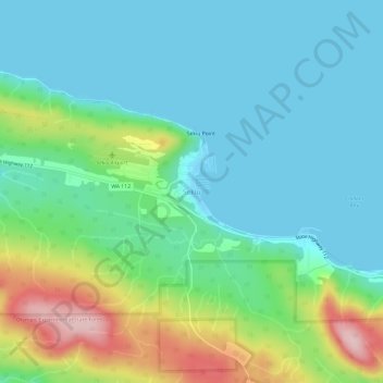
Nimi: Topografinen kartta Sekiu, korkeus, helpotus.
Paikka: Sekiu, Clallam County, Washington, United States (48.24230 -124.32133 48.28230 -124.28133)
Keskimääräinen korkeus: 59 m
Minimi korkeus: -2 m
Maksimi korkeus: 234 m
Tee lahjoitus
Muut topografiset kartat
Napsauta karttaa nähdäksesi sen topografian, sen korkeus ja sen helpotuksen.
Tee lahjoitus
Port Angeles East
United States > Washington > Clallam County > Mount Pleasant
Keskimääräinen korkeus: 59 m
Tee lahjoitus
Bell Hill
United States > Washington > Clallam County > Bell Hill
Bell Hill is located in eastern Clallam County and is bordered to the north by the city of Sequim. The community is named for the hill that it sits on, which rises to an elevation of over 1,000 feet (300 m) above sea level, or more than 800 feet (240 m) above the center of Sequim. Bell Hill actually has two…
Keskimääräinen korkeus: 139 m