
Tee lahjoitus
Topografinen kartta Lithia Springs
Napsauta karttaa nähdäksesi korkeus.
Tee lahjoitus
Tietoja tästä kartasta
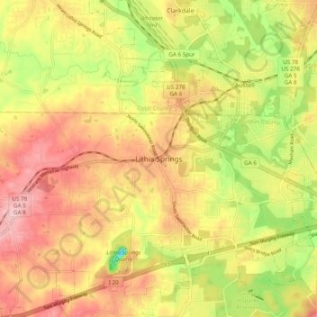
Nimi: Topografinen kartta Lithia Springs, korkeus, helpotus.
Keskimääräinen korkeus: 295 m
Minimi korkeus: 200 m
Maksimi korkeus: 367 m
Tee lahjoitus
Muut topografiset kartat
Napsauta karttaa nähdäksesi sen topografian, sen korkeus ja sen helpotuksen.
Douglasville
United States > Georgia > Douglas County
Located along a natural rise in the topography, Douglasville was originally known as "Skint Chestnut." The name was derived from a large tree used by Native Americans as a landmark; it was stripped of its bark so as to be more conspicuous.
Keskimääräinen korkeus: 310 m