
Tee lahjoitus
Topografinen kartta El Capitan
Napsauta karttaa nähdäksesi korkeus.
Tee lahjoitus
Tietoja tästä kartasta
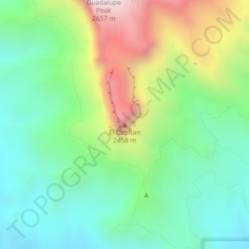
Nimi: Topografinen kartta El Capitan, korkeus, helpotus.
Paikka: El Capitan, Culberson County, Texas, 79847, United States (31.87729 -104.85805 31.87739 -104.85795)
Keskimääräinen korkeus: 1 916 m
Minimi korkeus: 1 564 m
Maksimi korkeus: 2 613 m
Tee lahjoitus
Muut topografiset kartat
Napsauta karttaa nähdäksesi sen topografian, sen korkeus ja sen helpotuksen.
Van Horn
United States > Texas > Culberson County
According to the United States Census Bureau, the town has a total area of 2.8 square miles (7.3 km2), all land. Threemile Peak, elevation 4,868 feet (1,484 m), rises to the northwest overlooking the town.
Keskimääräinen korkeus: 1 242 m
Guadalupe Mountains National Park
United States > Texas > Culberson County
The Guadalupe Mountains reach their highest point at Guadalupe Peak, the highest point in Texas, with an elevation of 8,751 feet (2,667 m). The range lies southeast of the Sacramento Mountains and east of the Brokeoff Mountains. The mountain range extends north-northwest and northeast from Guadalupe Peak in…
Keskimääräinen korkeus: 1 484 m
Tee lahjoitus
Van Horn
United States > Texas > Culberson County
According to the United States Census Bureau, the town has a total area of 2.8 square miles (7.3 km2), all land. Threemile Peak, elevation 4,868 feet (1,484 m), rises to the northwest overlooking the town.
Keskimääräinen korkeus: 1 242 m
Van Horn
United States > Texas > Culberson County
According to the United States Census Bureau, the town has a total area of 2.8 square miles (7.3 km2), all land. Threemile Peak, elevation 4,868 feet (1,484 m), rises to the northwest overlooking the town.
Keskimääräinen korkeus: 1 242 m