
Tee lahjoitus
Topografinen kartta Mingrelia-Upper Svaneti
Napsauta karttaa nähdäksesi korkeus.
Tee lahjoitus
Tietoja tästä kartasta
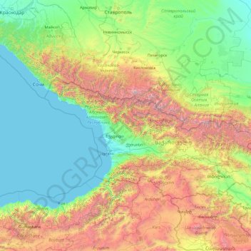
Nimi: Topografinen kartta Mingrelia-Upper Svaneti, korkeus, helpotus.
Paikka: Mingrelia-Upper Svaneti, Georgia (40.00427 39.58472 45.20427 44.78472)
Keskimääräinen korkeus: 916 m
Minimi korkeus: -1 m
Maksimi korkeus: 5 364 m
Tee lahjoitus
Muut topografiset kartat
Napsauta karttaa nähdäksesi sen topografian, sen korkeus ja sen helpotuksen.
Tbilisi
Most of the raions are named after historic quarters of the city. The citizens of Tbilisi widely recognise an informal system of smaller historic neighbourhoods. Such neighbourhoods are several, however, constituting a kind of hierarchy, because most of them have lost their distinctive topographic limits. The…
Keskimääräinen korkeus: 756 m
Abastumani
Georgia > Samtskhe-Javakheti > Adigeni Municipality
Abastumani (Georgian: აბასთუმანი) is a small town (daba) and climatic spa in Adigeni Municipality, Samtskhe-Javakheti, Georgia. It is located on the southern slopes of the Meskheti Range (Lesser Caucasus), in the small river valley of Otskhe, 25 km northeast of Adigeni and 28 km west of…
Keskimääräinen korkeus: 1 583 m
Tee lahjoitus
Lekhziri glacier
Georgia > Samegrelo-Upper Svaneti > Mestia Municipality
Keskimääräinen korkeus: 3 061 m
Tee lahjoitus
Tbilisi
Most of the raions are named after historic quarters of the city. The citizens of Tbilisi widely recognise an informal system of smaller historic neighborhoods. Such neighborhoods are several, however, constituting a kind of hierarchy, because most of them have lost their distinctive topographic limits. The…
Keskimääräinen korkeus: 756 m
Kutaisi
Kutaisi is located along both banks of the Rioni River. The city lies at an elevation of 125–300 metres (410–984 feet) above sea level. To the east and northeast Kutaisi is bounded by the Northern Imereti Foothills, to the north by the Samgurali Range, and to the west and the south by the Colchis Plain.
Keskimääräinen korkeus: 191 m
Algeti Reservoir
Georgia > Lower Kartli > Tetritskaro Municipality > Tbisi
Keskimääräinen korkeus: 869 m
Tee lahjoitus
Poti
Georgia > Samegrelo-Upper Svaneti
Poti is situated 312 kilometres (194 mi) west of Georgia’s capital, Tbilisi, in a marshy delta created by the major river of western Georgia, the Rioni, at its entrance into the Black Sea. The city lies at an altitude of 2 metres (6 feet 7 inches) above sea level. A portion of Poti's environs recovered from…
Keskimääräinen korkeus: 1 m
Kutaisi
Kutaisi is located along both banks of the Rioni River. The city lies at an elevation of 125–300 metres (410–984 feet) above sea level. To the east and northeast, Kutaisi is bounded by the Northern Imereti Foothills, to the north by the Samgurali Range, and to the west and the south by the Colchis Plain.
Keskimääräinen korkeus: 158 m
Tee lahjoitus
Tbilisi
Most of the raions are named after historic quarters of the city. The citizens of Tbilisi widely recognize an informal system of smaller historic neighborhoods. Such neighborhoods are several, however, constituting a kind of hierarchy, because most of them have lost their distinctive topographic limits. The…
Keskimääräinen korkeus: 756 m
Tbilisi
Most of the raions are named after historic quarters of the city. The citizens of Tbilisi widely recognise an informal system of smaller historic neighbourhoods. Such neighbourhoods are several, however, constituting a kind of hierarchy, because most of them have lost their distinctive topographic limits. The…
Keskimääräinen korkeus: 756 m
Kutaisi
Kutaisi is located along both banks of the Rioni River. The city lies at an elevation of 125–300 metres (410–984 feet) above sea level. To the east and northeast Kutaisi is bounded by the Northern Imereti Foothills, to the north by the Samgurali Range, and to the west and the south by the Colchis Plain.
Keskimääräinen korkeus: 158 m
Tee lahjoitus
Kakheti
The Kakheti Wine Region is located in the eastern part of Georgia and comprises two river basins, Iori and Alazani. These rivers have a significant influence on the character of Kakhetian wines. Kakheti is bordered on the west by another very important wine region of Georgia - Kartli. Together with the…
Keskimääräinen korkeus: 1 191 m
Tee lahjoitus
Gergeti Glacier
Georgia > Mtskheta-Mtianeti > Kazbegi Municipality
Gergeti (Georgian: გერგეთი; also known as Ortsveri) is a glacier located on the southeastern slope of Mt. Kazbek in the Kazbegi District of Georgia. The length of the Gergeti glacier is 7.1 km (4.4 mi) and its surface area is 11 km2 (4.2 sq mi). The tongue of Gergeti descends to 2,900 metres…
Keskimääräinen korkeus: 4 009 m
Tbilisi
Most of the raions are named after historic quarters of the city. The citizens of Tbilisi widely recognize an informal system of smaller historic neighborhoods. Such neighborhoods are several, however, constituting a kind of hierarchy, because most of them have lost their distinctive topographic limits. The…
Keskimääräinen korkeus: 756 m
Tee lahjoitus
Poti
Georgia > Samegrelo-Upper Svaneti
Poti is situated 312 kilometres (194 mi) west of Georgia’s capital, Tbilisi, in a marshy delta created by the major river of western Georgia, the Rioni, at its entrance into the Black Sea. The city lies at an altitude of 2 metres (6 feet 7 inches) above sea level. A portion of Poti's environs recovered from…
Keskimääräinen korkeus: 1 m
Shkhara Glacier
Georgia > Samegrelo-Upper Svaneti > Mestia Municipality
Keskimääräinen korkeus: 3 497 m
Pasanauri
Georgia > Mtskheta-Mtianeti > Dusheti Municipality
Pasanauri lies about 90 kilometres (56 mi) north of the nation's capital of Tbilisi, at elevation of 1,050 m. above sea level. Located on the Georgian Military Road, Pasanauri is flanked by the Aragvi River, and surrounded by the Caucasus Mountains. Average winter temperature is 0 degrees Celsius, but often…
Keskimääräinen korkeus: 1 507 m
Tee lahjoitus
Senaki
Georgia > Samegrelo-Upper Svaneti > Senaki Municipality
Senaki (Georgian: სენაკი, senak'i; Mingrelian: სანაკი, sanak'i) is a city in Samegrelo-Zemo Svaneti region, western Georgia. It is located at around 42°16′8″N 42°4′45″E / 42.26889°N 42.07917°E / 42.26889; 42.07917 between the rivers Tekhura/i and Tsivi, at an…
Keskimääräinen korkeus: 80 m
Tee lahjoitus
Zugdidi
Georgia > Samegrelo-Upper Svaneti > Zugdidi Municipality
Zugdidi (Georgian: ზუგდიდი [ˈz̪ugd̪id̪i]; Mingrelian: ზუგდიდი or ზუგიდი) is a city in the western Georgian historical province of Samegrelo (Mingrelia). It is situated in the north-west of that province. The city is located 318 kilometres west of Tbilisi, 30 km from…
Keskimääräinen korkeus: 111 m
Nokalakevi (Tsikhegoji)
Georgia > Samegrelo-Upper Svaneti > Senaki Municipality > Gakhomela
Keskimääräinen korkeus: 158 m
Gardabani
Georgia > Lower Kartli > Gardabani Municipality
Gardabani (Georgian: გარდაბანი) is a city of 11,650 residents (2021) in the valley or plain of the same name, in the southern Georgian region of Kvemo Kartli and is the administrative centre of the Gardabani Municipality. It is located 34 kilometres (21 mi) southeast of capital Tbilisi and 10…
Keskimääräinen korkeus: 299 m
Tee lahjoitus
Abudelauri White Lake
Georgia > Mtskheta-Mtianeti > Dusheti Municipality
Keskimääräinen korkeus: 3 050 m
Sarpi
Georgia > Autonomous Republic of Adjara > Khelvachauri Municipality
Keskimääräinen korkeus: 94 m
Tee lahjoitus
Bakuriani
Georgia > Samtskhe-Javakheti > Borjomi Municipality
Bakuriani (Georgian: ბაკურიანი) is a daba and a ski resort in the Borjomi district of Georgia. It is located on the northern slope of the Trialeti Range, at an elevation of 1,700 meters (5,576 feet) above sea level.
Keskimääräinen korkeus: 1 756 m
Tee lahjoitus
Sarpi
Georgia > Autonomous Republic of Adjara > Khelvachauri Municipality
Keskimääräinen korkeus: 94 m
Tbilisi
Most of the raions are named after historic quarters of the city. The citizens of Tbilisi widely recognize an informal system of smaller historic neighborhoods. Such neighborhoods are several, however, constituting a kind of hierarchy, because most of them have lost their distinctive topographic limits. The…
Keskimääräinen korkeus: 756 m
Stepantsminda
Georgia > Mtskheta-Mtianeti > Kazbegi Municipality
The town is located along the banks of the Terek River, 157 kilometers (98 mi) to the north of Tbilisi at an elevation of 1,740 meters (5,710 feet) above sea level. Stepantsminda’s climate is moderately humid with relatively dry, cold winters and long and cool summers. The average annual temperature is 4.9…
Keskimääräinen korkeus: 1 851 m
Tee lahjoitus
Tee lahjoitus
New Gudauri
Georgia > Mtskheta-Mtianeti > Kazbegi Municipality > Gudauri
Keskimääräinen korkeus: 2 162 m
Tabatskuri Lake
Georgia > Samtskhe-Javakheti > Akhalkalaki Municipality
Keskimääräinen korkeus: 2 055 m
Tee lahjoitus
Tbilisa Glacier
Georgia > Racha-Lechkhumi and Kvemo Svaneti > Oni Municipality
Keskimääräinen korkeus: 3 443 m
Tee lahjoitus
Machakhlistskali
Georgia > Autonomous Republic of Adjara > Khelvachauri Municipality > Machakhlispiri
Keskimääräinen korkeus: 777 m
Tee lahjoitus
Tee lahjoitus
Mestia
Georgia > Samegrelo-Upper Svaneti > Mestia Municipality
Mestia (Georgian: მესტია IPA: [mestʼia]) is a highland townlet (daba) in northwest Georgia, at an elevation of 1,500 metres (4,921 feet) in the Caucasus Mountains.
Keskimääräinen korkeus: 1 761 m
Tee lahjoitus
Racha-Lechkhumi and Kvemo Svaneti
Georgia > Racha-Lechkhumi and Kvemo Svaneti
Keskimääräinen korkeus: 1 654 m
Tbilisi
Most of the raions are named after historic quarters of the city. The citizens of Tbilisi widely recognise an informal system of smaller historic neighbourhoods. Such neighbourhoods are several, however, constituting a kind of hierarchy, because most of them have lost their distinctive topographic limits. The…
Keskimääräinen korkeus: 756 m
Tee lahjoitus
Bakuriani
Georgia > Samtskhe-Javakheti > Borjomi Municipality
Bakuriani (Georgian: ბაკურიანი) is a daba and a ski resort in the Borjomi district of Georgia. It is located on the northern slope of the Trialeti Range, at an elevation of 1,700 meters (5,576 feet) above sea level.
Keskimääräinen korkeus: 1 756 m
Shaori Reservoir
Georgia > Racha-Lechkhumi and Kvemo Svaneti > Ambrolauri Municipality > Kharistvala
Keskimääräinen korkeus: 1 281 m
Tee lahjoitus
Tetritskaro Municipality
Tetritskaro (Georgian: თეთრიწყაროს მუნიციპალიტეტი, Tetrićqaros Municiṕaliťeťi) is a district of Georgia, in the region of Kvemo Kartli. Its main town is Tetritskaro. Tetritskaro municipality is located in the eastern part of Georgia and is a self-governing…
Keskimääräinen korkeus: 1 025 m
Tee lahjoitus
Tee lahjoitus
Sighnaghi
Georgia > Signagi Municipality
The town has an area of 2.978 ha with 24.3% being residential. Signagi is approximately 113 km southeast of Tbilisi, the capital of Georgia. Signagi District is adjacent, on the town’s east and southwest sides. Signagi is situated in the eastern foothills of the Gombori Range, a watershed between the Iori…
Keskimääräinen korkeus: 739 m
Tee lahjoitus
Buba Glacier
Georgia > Racha-Lechkhumi and Kvemo Svaneti > Oni Municipality
Keskimääräinen korkeus: 3 398 m
Tee lahjoitus