
Tee lahjoitus
Topografinen kartta Denmark
Napsauta karttaa nähdäksesi korkeus.
Tee lahjoitus
Tietoja tästä kartasta
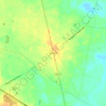
Nimi: Topografinen kartta Denmark, korkeus, helpotus.
Paikka: Denmark, Bulloch County, Georgia, United States (32.26463 -81.74400 32.30463 -81.70400)
Keskimääräinen korkeus: 45 m
Minimi korkeus: 29 m
Maksimi korkeus: 60 m
Tee lahjoitus
Muut topografiset kartat
Napsauta karttaa nähdäksesi sen topografian, sen korkeus ja sen helpotuksen.
Statesboro
United States > Georgia > Bulloch County
According to the United States Census Bureau, the city has a total area of 13.9 square miles (35.9 km2), of which 13.5 square miles (35.0 km2) is land and 0.35 square miles (0.9 km2), or 2.60%, is water. The city is in the coastal plain region, or Low Country, of Georgia, so it is mainly flat with a few small…
Keskimääräinen korkeus: 64 m
Tee lahjoitus
Statesboro
United States > Georgia > Bulloch County
According to the United States Census Bureau, the city has a total area of 13.9 square miles (35.9 km2), of which 13.5 square miles (35.0 km2) is land and 0.35 square miles (0.9 km2), or 2.60%, is water. The city is in the coastal plain region, or Low Country, of Georgia, so it is mainly flat with a few small…
Keskimääräinen korkeus: 64 m