
Tee lahjoitus
Topografinen kartta Four Corners
Napsauta karttaa nähdäksesi korkeus.
Tee lahjoitus
Tietoja tästä kartasta
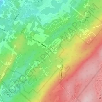
Nimi: Topografinen kartta Four Corners, korkeus, helpotus.
Keskimääräinen korkeus: 255 m
Minimi korkeus: 149 m
Maksimi korkeus: 382 m
Tee lahjoitus
Muut topografiset kartat
Napsauta karttaa nähdäksesi sen topografian, sen korkeus ja sen helpotuksen.
High Point State Park
United States > New Jersey > Sussex County > Montague Township
High Point State Park is a state park straddling the border of Wantage Township and Montague Township in Sussex County, within the Skylands Region of northwestern New Jersey, United States, near the border with New York State and Pennsylvania. The park covers 15,413 acres (62.37 km2). Part of the Kittatinny…
Keskimääräinen korkeus: 257 m
High Point State Park
United States > New Jersey > Sussex County > Montague Township
High Point State Park is a state park straddling the border of Wantage Township and Montague Township in Sussex County, within the Skylands Region of northwestern New Jersey, United States, near the border with New York State and Pennsylvania. The park covers 15,413 acres (62.37 km2). Part of the Kittatinny…
Keskimääräinen korkeus: 255 m