
Kiitos, että tuet tätä sivustoa ❤️
Tee lahjoitus
Tee lahjoitus
Topografinen kartta Al Rayyan
Napsauta karttaa nähdäksesi korkeus.
Kiitos, että tuet tätä sivustoa ❤️
Tee lahjoitus
Tee lahjoitus
Al Rayyan
The city's name derives from the Arabic word ray, which translates to "irrigation". It was given this name due to its low elevation, allowing it to act as a flood plain during the rainy season and provide a prolonged supply of water to the numerous wild plants and crops that grew in the area.
Kiitos, että tuet tätä sivustoa ❤️
Tee lahjoitus
Tee lahjoitus
Tietoja tästä kartasta
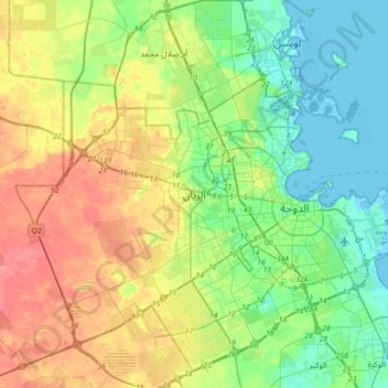
Nimi: Topografinen kartta Al Rayyan, korkeus, helpotus.
Paikka: Al Rayyan, Qatar (25.13662 51.27463 25.45662 51.59463)
Keskimääräinen korkeus: 21 m
Minimi korkeus: -3 m
Maksimi korkeus: 54 m
Kiitos, että tuet tätä sivustoa ❤️
Tee lahjoitus
Tee lahjoitus