
Kiitos, että tuet tätä sivustoa ❤️
Tee lahjoitus
Tee lahjoitus
Topografinen kartta Cooperville
Napsauta karttaa nähdäksesi korkeus.
Kiitos, että tuet tätä sivustoa ❤️
Tee lahjoitus
Tee lahjoitus
Tietoja tästä kartasta
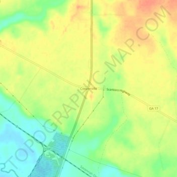
Nimi: Topografinen kartta Cooperville, korkeus, helpotus.
Paikka: Cooperville, Screven County, Georgia, United States (32.57073 -81.72400 32.61073 -81.68400)
Keskimääräinen korkeus: 47 m
Minimi korkeus: 22 m
Maksimi korkeus: 67 m
Kiitos, että tuet tätä sivustoa ❤️
Tee lahjoitus
Tee lahjoitus
Muut topografiset kartat
Napsauta karttaa nähdäksesi sen topografian, sen korkeus ja sen helpotuksen.
Sylvania
United States > Georgia > Screven County
According to the United States Census Bureau, the city has a total area of 3.8 square miles (9.8 km2), all land. Sylvania's elevation is 230 feet and is slightly higher than most of the land throughout Screven County.
Keskimääräinen korkeus: 60 m