
Kiitos, että tuet tätä sivustoa ❤️
Tee lahjoitus
Tee lahjoitus
Topografinen kartta Kriskhevi
Napsauta karttaa nähdäksesi korkeus.
Kiitos, että tuet tätä sivustoa ❤️
Tee lahjoitus
Tee lahjoitus
Tietoja tästä kartasta
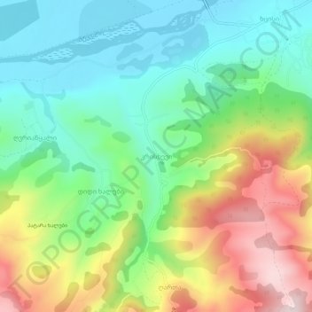
Nimi: Topografinen kartta Kriskhevi, korkeus, helpotus.
Paikka: Kriskhevi, Khashuri Municipality, Shida Kartli, Georgia (41.94574 43.63428 41.98574 43.67428)
Keskimääräinen korkeus: 848 m
Minimi korkeus: 676 m
Maksimi korkeus: 1 154 m
Kiitos, että tuet tätä sivustoa ❤️
Tee lahjoitus
Tee lahjoitus
Muut topografiset kartat
Napsauta karttaa nähdäksesi sen topografian, sen korkeus ja sen helpotuksen.
Mtkvari
Georgia > Shida Kartli > Khashuri Municipality > Rbona
Most of the Kura runs in the broad and deep valley between the Greater Caucasus and Lesser Caucasus Mountains, and the major tributary, the Aras, drains most of the southern Caucasus and the mountain ranges of the extreme northern Middle East. The entirety of Armenia and most of Azerbaijan are drained by the…
Keskimääräinen korkeus: 781 m