
Tee lahjoitus
Topografinen kartta Eden
Napsauta karttaa nähdäksesi korkeus.
Tee lahjoitus
Eden
Eden is a census-designated place in Weber County, Utah, United States. It is home to Powder Mountain ski resort. It lies between the North and Middle Fork of the Ogden River, north of Pineview Reservoir, in the Ogden Valley. The elevation is 4,941 feet (1,506 m). The population was 600 at the 2010 census. It has a post office with the ZIP code 84310. Eden is part of the Ogden–Clearfield, Utah Metropolitan Statistical Area, as well as the Ogden Valley census county division
Tee lahjoitus
Tietoja tästä kartasta
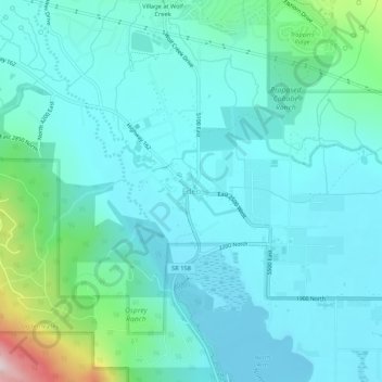
Nimi: Topografinen kartta Eden, korkeus, helpotus.
Paikka: Eden, Weber County, Utah, 84310, United States (41.28447 -111.84630 41.32447 -111.80630)
Keskimääräinen korkeus: 1 562 m
Minimi korkeus: 1 484 m
Maksimi korkeus: 1 964 m
Tee lahjoitus
Muut topografiset kartat
Napsauta karttaa nähdäksesi sen topografian, sen korkeus ja sen helpotuksen.
Ogden
United States > Utah > Weber County
According to the United States Census Bureau, the city has an area of 26.6 square miles (69.0 km2), all land. Elevations in the city range from about 4,300 to 5,000 feet (1,300 to 1,500 m) above sea level.
Keskimääräinen korkeus: 1 498 m
Ogden
United States > Utah > Weber County
According to the United States Census Bureau, the city has an area of 26.6 square miles (69.0 km2), all land. Elevations in the city range from about 4,300 to 5,000 feet (1,300 to 1,500 m) above sea level.
Keskimääräinen korkeus: 1 498 m
Tee lahjoitus
Tee lahjoitus
Ogden
United States > Utah > Weber County
According to the United States Census Bureau, the city has an area of 26.6 square miles (69 km2), all land. Elevations in the city range from about 4,300 to 5,000 feet (1,300 to 1,500 m) above sea level.
Keskimääräinen korkeus: 1 498 m
Tee lahjoitus
Tee lahjoitus
Ogden
United States > Utah > Weber County
According to the United States Census Bureau, the city has an area of 26.6 square miles (69.0 km2), all land. Elevations in the city range from about 4,300 to 5,000 feet (1,300 to 1,500 m) above sea level.
Keskimääräinen korkeus: 1 498 m
Tee lahjoitus