Geolocate

Topografinen kartta Mableton

Napsauta karttaa nähdäksesi korkeus.

Tietoja tästä kartasta

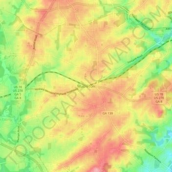
Nimi: Topografinen kartta Mableton, korkeus, helpotus.

Paikka: Mableton, Cobb County, Georgia, 30168, United States (33.77883 -84.62226 33.85883 -84.54226)

Keskimääräinen korkeus: 298 m

Minimi korkeus: 234 m

Maksimi korkeus: 356 m

Muut topografiset kartat

Napsauta karttaa nähdäksesi sen topografian, sen korkeus ja sen helpotuksen.

Acworth

United States > Georgia > Cobb County

Keskimääräinen korkeus: 281 m

Mableton

United States > Georgia > Cobb County

Keskimääräinen korkeus: 287 m

Marietta

United States > Georgia > Cobb County

Keskimääräinen korkeus: 323 m

Austell

United States > Georgia > Cobb County

Keskimääräinen korkeus: 289 m

Kennesaw

United States > Georgia > Cobb County

Kennesaw is located in northwestern Cobb County, bordered by the city of Acworth to the northwest. Kennesaw Mountain is located southeast of the city limits in the battlefield park. Its summit is the highest point in the Atlanta metro area, at an elevation of 1,808 feet (551 m) above sea level. The city was…

Keskimääräinen korkeus: 317 m

Powder Springs

United States > Georgia > Cobb County

Keskimääräinen korkeus: 291 m

Smyrna

United States > Georgia > Cobb County

Keskimääräinen korkeus: 289 m

Vinings

United States > Georgia > Cobb County > Vinings

Keskimääräinen korkeus: 278 m

Lake Acworth

United States > Georgia > Cobb County > Acworth

Keskimääräinen korkeus: 273 m

Marietta

United States > Georgia > Cobb County

Keskimääräinen korkeus: 323 m

Marietta

United States > Georgia > Cobb County

Keskimääräinen korkeus: 323 m

Marietta

United States > Georgia > Cobb County

Keskimääräinen korkeus: 323 m

Mableton

United States > Georgia > Cobb County

Keskimääräinen korkeus: 287 m

Smyrna

United States > Georgia > Cobb County

Keskimääräinen korkeus: 289 m

Acworth

United States > Georgia > Cobb County

Keskimääräinen korkeus: 281 m

Marietta

United States > Georgia > Cobb County

Keskimääräinen korkeus: 323 m

Aboretum

United States > Georgia > Cobb County

Keskimääräinen korkeus: 319 m

Kennesaw

United States > Georgia > Cobb County

Kennesaw is located in northwestern Cobb County, bordered by the city of Acworth to the northwest. Kennesaw Mountain is located southeast of the city limits in the battlefield park. Its summit is the highest point in the Atlanta metro area, at an elevation of 1,808 feet (551 m) above sea level. The city was…

Keskimääräinen korkeus: 317 m

Powder Springs

United States > Georgia > Cobb County

Keskimääräinen korkeus: 291 m