
Kiitos, että tuet tätä sivustoa ❤️
Tee lahjoitus
Tee lahjoitus
Topografinen kartta Dolomite
Napsauta karttaa nähdäksesi korkeus.
Kiitos, että tuet tätä sivustoa ❤️
Tee lahjoitus
Tee lahjoitus
Tietoja tästä kartasta
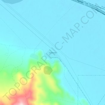
Nimi: Topografinen kartta Dolomite, korkeus, helpotus.
Paikka: Dolomite, Tooele County, Utah, United States (40.68313 -112.59586 40.72313 -112.55586)
Keskimääräinen korkeus: 1 324 m
Minimi korkeus: 1 278 m
Maksimi korkeus: 1 598 m
Kiitos, että tuet tätä sivustoa ❤️
Tee lahjoitus
Tee lahjoitus
Muut topografiset kartat
Napsauta karttaa nähdäksesi sen topografian, sen korkeus ja sen helpotuksen.
Kiitos, että tuet tätä sivustoa ❤️
Tee lahjoitus
Tee lahjoitus
Lake Point
United States > Utah > Tooele County
John C. Frémont, a second lieutenant in the U.S. Army Corps of Topographical Engineers, was commissioned by the US Government to explore the Mexican territory west of the Louisiana Purchase with a special interest in the terrain and various routes that could link the Midwest to California. In the summer of…
Keskimääräinen korkeus: 1 425 m