
Tee lahjoitus
Topografinen kartta Briggs
Napsauta karttaa nähdäksesi korkeus.
Tee lahjoitus
Briggs
Briggs lies along U.S. Route 183 and FM 2657, northeast of Burnet. Its elevation is 1,102 feet (336 m), and it is located at 30°53′23″N 97°55′30″W / 30.88972°N 97.92500°W / 30.88972; -97.92500. Although Briggs is unincorporated, it has a post office, with the ZIP code of 78608. The population was 101 at the 2020 census.
Tee lahjoitus
Tietoja tästä kartasta
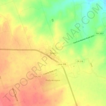
Nimi: Topografinen kartta Briggs, korkeus, helpotus.
Paikka: Briggs, Burnet County, Texas, 78608, United States (30.86877 -97.94581 30.90877 -97.90581)
Keskimääräinen korkeus: 336 m
Minimi korkeus: 295 m
Maksimi korkeus: 362 m
Tee lahjoitus
Muut topografiset kartat
Napsauta karttaa nähdäksesi sen topografian, sen korkeus ja sen helpotuksen.
Inks Lake State Park
United States > Texas > Burnet County > Burnet
Conservation Pool Elevation usually stays around 888.22 ft. msl; however, this lake does fluctuate about 1 foot annually. Inks lake water clarity can be seen as clear to slightly stained mostly throughout the year. It tends to have higher turbidity during the rainy season due to excessive amounts of runoff.
Keskimääräinen korkeus: 294 m
Tee lahjoitus
Tee lahjoitus