
Tee lahjoitus
Topografinen kartta Mount Meron
Napsauta karttaa nähdäksesi korkeus.
Tee lahjoitus
Mount Meron
In 1965, an 84,000-dunam nature reserve was declared. An additional 1,199 dunams were declared part of the reserve in 2005. It is the highest reserve in Israel, at an altitude of 1,204 meters above sea level, and the largest reserve in the north of the country.
Tee lahjoitus
Tietoja tästä kartasta
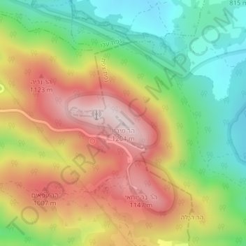
Nimi: Topografinen kartta Mount Meron, korkeus, helpotus.
Keskimääräinen korkeus: 943 m
Minimi korkeus: 717 m
Maksimi korkeus: 1 194 m
Tee lahjoitus
Muut topografiset kartat
Napsauta karttaa nähdäksesi sen topografian, sen korkeus ja sen helpotuksen.
Tee lahjoitus
Meron
Israel > North District > Merom HaGalil Regional Council
Meron is noted for its mountainous terrain and valleys. Among the local attractions are the Meron Vineyards. Meron is conducive to growing grapes for wine as a result of its 600-meter altitude and chalky soil. The vineyard was first planted in 2000 and is part of the Galil Mountain Winery, headquartered in…
Keskimääräinen korkeus: 735 m