
Tee lahjoitus
Topografinen kartta Ballymoney
Napsauta karttaa nähdäksesi korkeus.
Tee lahjoitus
Ballymoney
In 1837, Lewis's Topographical Dictionary of Ireland, describes Ballymoney as "a market-town and post-town" containing 2,222 inhabitants (11,579 in the broader civil parish) with a long established linen market chiefly supplying the London market, and with "a very extensive trade ... in grain, butter, pork, and general provisions". Transport was largely via the Bann. By 1860, the town was connected to both Belfast and Derry by rail.
Tee lahjoitus
Tietoja tästä kartasta
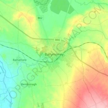
Nimi: Topografinen kartta Ballymoney, korkeus, helpotus.
Keskimääräinen korkeus: 51 m
Minimi korkeus: 0 m
Maksimi korkeus: 137 m
Tee lahjoitus
Muut topografiset kartat
Napsauta karttaa nähdäksesi sen topografian, sen korkeus ja sen helpotuksen.
Botanic Gardens
United Kingdom > Northern Ireland > County Antrim > Belfast
Keskimääräinen korkeus: 15 m
Rathlin Island
United Kingdom > Northern Ireland > County Antrim > Church Bay
Keskimääräinen korkeus: 10 m
Tee lahjoitus
Loughgiel Millennium Centre
United Kingdom > Northern Ireland > County Antrim > Loughguile
Keskimääräinen korkeus: 155 m
Ballygomartin
United Kingdom > Northern Ireland > County Antrim > Belfast
Keskimääräinen korkeus: 258 m
Tee lahjoitus
Shane's Castle Park
United Kingdom > Northern Ireland > County Antrim > Randalstown
Keskimääräinen korkeus: 30 m
Lagan Navigation (Abandoned)
United Kingdom > Northern Ireland > County Antrim > Belfast
Keskimääräinen korkeus: 29 m
Mid and East Antrim District
United Kingdom > Northern Ireland > County Antrim
Keskimääräinen korkeus: 111 m
Tee lahjoitus
Antrim and Newtownabbey District
United Kingdom > Northern Ireland > County Antrim
Keskimääräinen korkeus: 97 m
Kilroot
United Kingdom > Northern Ireland > County Antrim > Carrickfergus
Keskimääräinen korkeus: 28 m
Tee lahjoitus
Causeway Coast AONB
United Kingdom > Northern Ireland > County Antrim > Ballintoy
Keskimääräinen korkeus: 34 m
Tamybuck
United Kingdom > Northern Ireland > County Antrim > Aughafatten
Keskimääräinen korkeus: 171 m
Kinbane Castle
United Kingdom > Northern Ireland > County Antrim > Ballycastle
Keskimääräinen korkeus: 37 m
Rathlin Island
United Kingdom > Northern Ireland > County Antrim > Church Bay
Keskimääräinen korkeus: 10 m
Tee lahjoitus
Antrim and Newtownabbey District
United Kingdom > Northern Ireland > County Antrim
Keskimääräinen korkeus: 97 m
Tee lahjoitus
Tee lahjoitus
Tee lahjoitus
Mid and East Antrim District
United Kingdom > Northern Ireland > County Antrim
Keskimääräinen korkeus: 111 m
Tee lahjoitus
Antrim and Newtownabbey District
United Kingdom > Northern Ireland > County Antrim
Keskimääräinen korkeus: 97 m