
Kiitos, että tuet tätä sivustoa ❤️
Tee lahjoitus
Tee lahjoitus
Topografinen kartta Al Hayr
Napsauta karttaa nähdäksesi korkeus.
Kiitos, että tuet tätä sivustoa ❤️
Tee lahjoitus
Tee lahjoitus
Tietoja tästä kartasta
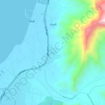
Nimi: Topografinen kartta Al Hayr, korkeus, helpotus.
Paikka: Al Hayr, Ras al-Khaimah, United Arab Emirates (25.96537 56.06295 26.00537 56.10295)
Keskimääräinen korkeus: 102 m
Minimi korkeus: 0 m
Maksimi korkeus: 744 m
Kiitos, että tuet tätä sivustoa ❤️
Tee lahjoitus
Tee lahjoitus
Muut topografiset kartat
Napsauta karttaa nähdäksesi sen topografian, sen korkeus ja sen helpotuksen.
Wadi Kub
United Arab Emirates > Ras al-Khaimah > Kub
In its upper course, the wadi is formed by two arms of similar length and flow, which originate at approximately an altitude of 542 m (1,778 ft); they border Al Jaroof to the east and west, respectively; and converge to the south of this town, defining the main channel, which initially follows the direction…
Keskimääräinen korkeus: 324 m
Kiitos, että tuet tätä sivustoa ❤️
Tee lahjoitus
Tee lahjoitus
Kiitos, että tuet tätä sivustoa ❤️
Tee lahjoitus
Tee lahjoitus