
Tee lahjoitus
Topografinen kartta Rescue
Napsauta karttaa nähdäksesi korkeus.
Tee lahjoitus
Rescue
Rescue, formerly Green Valley, El Dorado County, California, is an unincorporated community in El Dorado County, California. It is located north-northwest of Shingle Springs and north-northeast of Cameron Park. The zip code is 95672, and Rescue is located in area code 530. The town lies at an elevation of 1214 feet (370 m).
Tee lahjoitus
Tietoja tästä kartasta
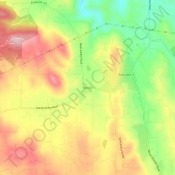
Nimi: Topografinen kartta Rescue, korkeus, helpotus.
Paikka: Rescue, El Dorado County, California, 95672, United States (38.69167 -120.97139 38.73167 -120.93139)
Keskimääräinen korkeus: 393 m
Minimi korkeus: 267 m
Maksimi korkeus: 507 m
Tee lahjoitus
Muut topografiset kartat
Napsauta karttaa nähdäksesi sen topografian, sen korkeus ja sen helpotuksen.
Diamond Springs
United States > California > El Dorado County
Diamond Springs (formerly, Diamond Spring and Diamond) is a census-designated place (CDP) in El Dorado County, California, United States. It is part of the Sacramento–Arden-Arcade–Roseville Metropolitan Statistical Area. The population was 11,037 at the 2010 census, up from 4,888 at the 2000 census. The…
Keskimääräinen korkeus: 531 m
Lake Tahoe Basin Management Unit
United States > California > El Dorado County
The Lake Tahoe Basin Management Unit is a United States National Forest that manages and protects public land surrounding Lake Tahoe and the Lake Tahoe Basin. Straddling the state borders of California and Nevada in the Sierra Nevada, the LTBMU encompasses 154,851 acres (626 km²) of National Forest system…
Keskimääräinen korkeus: 1 981 m
Eldorado National Forest
United States > California > El Dorado County
The forest ranges in elevation from 1,000 feet (300 m) in the foothills to more than 10,000 feet (3,000 m) above sea level along the Sierra crest. The mountainous topography is broken by the steep canyons of the Mokelumne, Cosumnes, American, and Rubicon rivers. Plateaus of generally moderate relief are…
Keskimääräinen korkeus: 1 807 m
Fallen Leaf Lake
United States > California > El Dorado County
The surface elevation of the lake is 152 feet (46 m) above Lake Tahoe.
Keskimääräinen korkeus: 2 068 m
Tee lahjoitus
Diamond Springs
United States > California > El Dorado County
Diamond Springs (formerly, Diamond Spring and Diamond) is a census-designated place (CDP) in El Dorado County, California, United States. It is part of the Sacramento–Arden-Arcade–Roseville Metropolitan Statistical Area. The population was 11,037 at the 2010 census, up from 4,888 at the 2000 census. The…
Keskimääräinen korkeus: 531 m
Laurel Oaks Park
United States > California > El Dorado County > Cameron Park > Bar J Ranch
Keskimääräinen korkeus: 380 m
Tee lahjoitus
South Lake Tahoe-El Dorado Recreation Area
United States > California > El Dorado County > South Lake Tahoe > Bijou
Keskimääräinen korkeus: 1 905 m
El Dorado Hills
United States > California > El Dorado County > Folsom
El Dorado Hills (EDH), as defined by the 2010 census-designated place (CDP), is at the western border of El Dorado County, between the City of Folsom and the unincorporated community of Cameron Park. The northern limits of the CDP are Folsom Lake and the South Fork of the American River, where river rafters…
Keskimääräinen korkeus: 243 m
Tee lahjoitus