
Kiitos, että tuet tätä sivustoa ❤️
Tee lahjoitus
Tee lahjoitus
Topografinen kartta Chestatee North
Napsauta karttaa nähdäksesi korkeus.
Kiitos, että tuet tätä sivustoa ❤️
Tee lahjoitus
Tee lahjoitus
Tietoja tästä kartasta
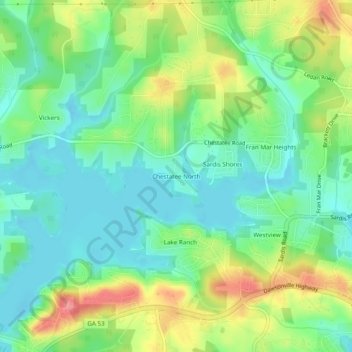
Nimi: Topografinen kartta Chestatee North, korkeus, helpotus.
Paikka: Chestatee North, Hall County, Georgia, 30506, United States (34.32593 -83.93935 34.36593 -83.89935)
Keskimääräinen korkeus: 353 m
Minimi korkeus: 322 m
Maksimi korkeus: 411 m
Kiitos, että tuet tätä sivustoa ❤️
Tee lahjoitus
Tee lahjoitus
Muut topografiset kartat
Napsauta karttaa nähdäksesi sen topografian, sen korkeus ja sen helpotuksen.
Kiitos, että tuet tätä sivustoa ❤️
Tee lahjoitus
Tee lahjoitus
Sterling on the Lake Dam #1
United States > Georgia > Hall County > Flowery Branch
Keskimääräinen korkeus: 299 m
Kiitos, että tuet tätä sivustoa ❤️
Tee lahjoitus
Tee lahjoitus