
Kiitos, että tuet tätä sivustoa ❤️
Tee lahjoitus
Tee lahjoitus
Topografinen kartta Strickland Heights
Napsauta karttaa nähdäksesi korkeus.
Kiitos, että tuet tätä sivustoa ❤️
Tee lahjoitus
Tee lahjoitus
Tietoja tästä kartasta
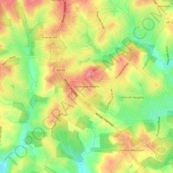
Nimi: Topografinen kartta Strickland Heights, korkeus, helpotus.
Paikka: Strickland Heights, Hall County, Georgia, United States (34.16733 -83.87018 34.20733 -83.83018)
Keskimääräinen korkeus: 325 m
Minimi korkeus: 275 m
Maksimi korkeus: 368 m
Kiitos, että tuet tätä sivustoa ❤️
Tee lahjoitus
Tee lahjoitus
Muut topografiset kartat
Napsauta karttaa nähdäksesi sen topografian, sen korkeus ja sen helpotuksen.
Kiitos, että tuet tätä sivustoa ❤️
Tee lahjoitus
Tee lahjoitus
Sterling on the Lake Dam #1
United States > Georgia > Hall County > Flowery Branch
Keskimääräinen korkeus: 299 m
Kiitos, että tuet tätä sivustoa ❤️
Tee lahjoitus
Tee lahjoitus