
Kiitos, että tuet tätä sivustoa ❤️
Tee lahjoitus
Tee lahjoitus
Topografinen kartta Eureka
Napsauta karttaa nähdäksesi korkeus.
Kiitos, että tuet tätä sivustoa ❤️
Tee lahjoitus
Tee lahjoitus
Eureka
The city marina is on one of three islands at a narrow point on the 13-mile-long (21 km) bay and increases in elevation slightly as it spreads north, south, and especially to the east. The city gently encroaches at least two miles (3.2 km) eastward into primarily Redwood and Douglas-fir second growth forests. The city has a traditional grid that generally radiates toward the points of the compass. Most post-1970 houses were built in formerly clear cut forested areas.
Kiitos, että tuet tätä sivustoa ❤️
Tee lahjoitus
Tee lahjoitus
Tietoja tästä kartasta
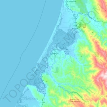
Nimi: Topografinen kartta Eureka, korkeus, helpotus.
Paikka: Eureka, Humboldt County, California, 95502, United States (40.63069 -124.32737 40.95069 -124.00737)
Keskimääräinen korkeus: 100 m
Minimi korkeus: -5 m
Maksimi korkeus: 854 m
Kiitos, että tuet tätä sivustoa ❤️
Tee lahjoitus
Tee lahjoitus