
Kiitos, että tuet tätä sivustoa ❤️
Tee lahjoitus
Tee lahjoitus
Topografinen kartta Sierra Blanca
Napsauta karttaa nähdäksesi korkeus.
Kiitos, että tuet tätä sivustoa ❤️
Tee lahjoitus
Tee lahjoitus
Sierra Blanca
Sierra Blanca is found in Far West Texas, a subdivision of West Texas, and is 4,520 feet (1,380 m) above sea level. The town is part of the Trans-Pecos region within the most mountainous and arid portion of Texas. The town is located in Hudspeth County, which is large and sparsely populated. Sierra Blanca (White Mountain), at an elevation of 6,892 feet (2,101 m) above sea level, towers over the town to the northwest and is the most prominent mountain peak of the surrounding mountainous terrain.
Kiitos, että tuet tätä sivustoa ❤️
Tee lahjoitus
Tee lahjoitus
Tietoja tästä kartasta
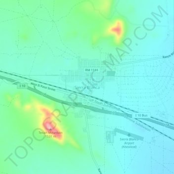
Nimi: Topografinen kartta Sierra Blanca, korkeus, helpotus.
Keskimääräinen korkeus: 1 391 m
Minimi korkeus: 1 355 m
Maksimi korkeus: 1 542 m
Kiitos, että tuet tätä sivustoa ❤️
Tee lahjoitus
Tee lahjoitus
Muut topografiset kartat
Napsauta karttaa nähdäksesi sen topografian, sen korkeus ja sen helpotuksen.