
Tee lahjoitus
Topografinen kartta Waterfall
Napsauta karttaa nähdäksesi korkeus.
Tee lahjoitus
Tietoja tästä kartasta
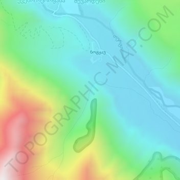
Nimi: Topografinen kartta Waterfall, korkeus, helpotus.
Paikka: Waterfall, Kazbegi Municipality, Mtskheta-Mtianeti, Georgia (42.56953 44.47218 42.56963 44.47228)
Keskimääräinen korkeus: 2 314 m
Minimi korkeus: 1 974 m
Maksimi korkeus: 3 193 m
Tee lahjoitus
Muut topografiset kartat
Napsauta karttaa nähdäksesi sen topografian, sen korkeus ja sen helpotuksen.
New Gudauri
Georgia > Mtskheta-Mtianeti > Kazbegi Municipality > Gudauri
Keskimääräinen korkeus: 2 162 m
Gergeti Glacier
Georgia > Mtskheta-Mtianeti > Kazbegi Municipality
Gergeti (Georgian: გერგეთი; also known as Ortsveri) is a glacier located on the southeastern slope of Mt. Kazbek in the Kazbegi District of Georgia. The length of the Gergeti glacier is 7.1 km (4.4 mi) and its surface area is 11 km2 (4.2 sq mi). The tongue of Gergeti descends to 2,900 metres…
Keskimääräinen korkeus: 4 009 m
Tee lahjoitus
Stepantsminda
Georgia > Mtskheta-Mtianeti > Kazbegi Municipality
The town is located along the banks of the Terek River, 157 kilometers (98 mi) to the north of Tbilisi at an elevation of 1,740 meters (5,710 feet) above sea level. Stepantsminda’s climate is moderately humid with relatively dry, cold winters and long and cool summers. The average annual temperature is 4.9…
Keskimääräinen korkeus: 1 851 m