
Kiitos, että tuet tätä sivustoa ❤️
Tee lahjoitus
Tee lahjoitus
Topografinen kartta Berg
Napsauta karttaa nähdäksesi korkeus.
Kiitos, että tuet tätä sivustoa ❤️
Tee lahjoitus
Tee lahjoitus
Tietoja tästä kartasta
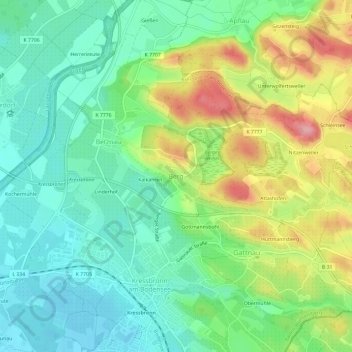
Nimi: Topografinen kartta Berg, korkeus, helpotus.
Keskimääräinen korkeus: 443 m
Minimi korkeus: 396 m
Maksimi korkeus: 530 m
Kiitos, että tuet tätä sivustoa ❤️
Tee lahjoitus
Tee lahjoitus
Muut topografiset kartat
Napsauta karttaa nähdäksesi sen topografian, sen korkeus ja sen helpotuksen.
Friedrichshafen
Germany > Baden-Württemberg > Bodenseekreis
Friedrichshafen is located on a gently curved bay on the north shore of Lake Constance and on the southwest edge of the Schussen. The city is over an altitude of 395.2 m above sea level. NHH on the shores of Lake Constance up to 501.6 m in Ailingen. The core city is located not far to the west of the…
Keskimääräinen korkeus: 441 m
Kiitos, että tuet tätä sivustoa ❤️
Tee lahjoitus
Tee lahjoitus